

Beyond C2000, realizing a location based services platform for the Dutch emergency services
pMaster’s Thesis, Pooya Obbohat, October 2007
This Master’s thesis is part of the two-year English-language full-time System Engineering, Policy Analysis and Management (SEPAM) Master of Science programme. This programme is given at the faculty of Technology, Policy and Management of the Delft University of Technology in the Netherlands. The aim of this programme is to provide students the capability to transfer their obtained knowledge of the Bachelor’s programme into designing future sociotechnical systems. This is done by integrating the rational know-how of technology into the dynamic and fuzzy world of management practice [32].
The thesis is accompanied by a paper closely linked to its topic. The research done for this thesis has been conducted under the supervision of the public sector of LogicaCMG in the Netherlands, which is situated in Rijswijk. LogicaCMG Netherlands has recently started a programme which is called “Working Tomorrow” aimed at providing students the possibility to conduct research on innovative technologies. Where most of the researches focus on technological aspects, some also focus on managerial issues technological innovations bring fourth. This specific research addressed both technological and organizational elements. The subject of this research has attracted my interest because of its high societal relevance, but also because of the complexity that has to be addressed in order to come up with a feasible design facing a diverse set of strict conditions and requirements.
The research is partly based on interviews with respondents from the different involved organizations. I would like to thank all of the respondents for their time, the sharing of their knowledge and their interest in my research.
I would also like to take this opportunity to express my gratitude to the following people: Jan van den Berg for his feedback and supervision of the research, Harry Bouwman for giving critical feedback needed to levitate the scientifical level of this thesis, Martijn Leijten for his feedback concerning the organizational parts of the thesis, my supervisors at LogicaCMG, Richard van Haaren, Ilske Verburg and Gideon Bazen for their feedback, dedication and time, Wilbert van der Kolk, Hans Lammers and Laurens Lapré for sharing their experiences and validation of the designs, my fellow trainees, Rob van Duijn, Renze de Vries, Silvion Moesan and Dogan Günay for their feedback and creative input, my brother Nima Obbohat, for sharing his expertise and reviewing my thesis, Nitesh Bharosa for keeping me on the scientifical track and Pieter Goossen for connecting me to the right people. Finally I would like to dedicate this thesis and the accompanying paper to my mom, Mitra Sarhangi, who has made all of this possible in so many ways.
Pooya Obbohat
Delft, the Netherlands, October 1st, 2007
Executive summary
Which positioning platform is most suited for the Dutch emergency services? The answer to this question is found by giving answers to several sub-questions which together result in a conceptual design of a suitable positioning platform. This design consists of both technological and organizational elements. In order to come up with this design, both the technological and the organizational conditions and requirements have been determined. This is done by conducting interviews with key people of all the stakeholders and by performing a literature study. Next to determining the conditions and requirements, it is also important to understand the variables that have to be used for the design and how they can be chosen. This is done by examining all the conditions and requirements and looking for consistent patterns. The second research phase is then used to analyze how each variable can be addressed, which can be seen as the scanning of the technological and organizational options. This is done by performing an extensive literature study and by developing a modelling tool which can make the most important aspects of the organizational part of the design more concrete.
At first sight the technological and the organizational conditions and requirements limit the available options severely. By looking at different scenarios and taking into account an expected development path which also addresses future needs, it is made clear what the ideal solution should be. The ideal solution is the realization of a positioning platform which addresses the need for outdoor and indoor positioning and the exchange of large amounts of data towards and from mobile devices used by the emergency services. This is based on the future Galileo Positioning System, the EGNOS augmentation network which is expected to be operational at the same time, pseudolite technology enabling ubiquitous positioning and a WiMAX network which is able to provide the exchange of large amounts of data. The downside of this solution is the unavailability of the technologies at this moment. This solution which isn’t realizable in the near future poses the problem that no short-term solution is provided for the existing need for positioning services. This triggered the design of a temporary solution which can be used to bridge the time towards the realization of the ideal solution. This first phase is based on the Mobitex network, regular GPS positioning and the option to use RDS-dGPS or the Global DGPS network to realize more accurate positioning.
A bottom-up development of positioning services is recognized, which emphasizes the expressed need for an immediate positioning platform. The temporary positioning platform is focussed on providing a flexible solution just for this purpose, which is needed because important conditions of the emergency services can’t be met in a feasible short-term solution. Flexibility is given by allowing the ambulance care to choose whether or not to participate during this first phase and by allowing the emergency services to determine themselves whether or not it is important to have more accurate positioning services. This first phase is also used to gain experience and familiarize the emergency services with the approach used in the second phase. Regional servers are implemented and the emergency services are thereby forced to come up with nationally standardized peripheral equipment for their own discipline when possible and regionally standardized applications for positioning services. Other data can be sent by using the available commercial networks based on UMTS or HSDPA, which are also used to send multidisciplinary positioning information during disasters and tests.
The second platform phase design builds on the first phase by using the same regional servers. Next to using some new technologies it now provides the ability to exchange large amounts of data. This can be done physically, where the positioning services are only provided virtually by using regionally implemented monodisciplinary application servers. The emergency services aren’t forced to come up with a general application, but can develop applications specifically for their own discipline. They are on the other hand obliged to realize this at least regionally and negotiate connections of third parties systems with their positioning information at the same level. This in fact means that no local emergency service is able to physically obtain positioning information, but that they are offered this information virtually via the applications servers. By making use of the role the emergency control centres are playing and the fact that they are being integrated, it is possible to delegate the responsibility of determining when multidisciplinary information is needed and when it isn’t. The operations of the emergency control centres have been automated to a certain degree by using the integrated emergency control centre system (GMS) and its follow-up (NMS) currently being developed. By utilizing this software to take into account authorization levels linked to portable devices and a list of scenarios, it is possible to push multidisciplinary information when needed and prevent this from happening during normal operations.
Because of the limited time available for this research, it is strongly recommended to follow a set of evaluation steps. These steps more or less represent the different research methods that have been used to come up with the technological architecture and the organizational arrangements.
1 Introduction
This thesis is based on a research which has been conducted under supervision of LogicaCMG. It provides a description on how it was conducted and presents the results which were attained. This chapter starts out by elaborating on the context of this research by providing some background information which might be needed to understand the topic. This is followed by a section on its scope, presenting the research objective, the research questions and the research constraints. The third section provides a description of the research methods by looking at the methodological framework and finally the last section indicates the way this thesis has been structured.
1.1 Research context
This research has been done with the aim of providing a conceptual design of a positioning platform for the Dutch emergency services. Here we consider a positioning platform to be a technological foundation with the needed amount of corresponding organizational arrangements, on which applications can be built that take into account the location of the user of the system. The users of this system are the Dutch emergency services and other affiliated organizations. In order to realize this agreements have to be made on both the technological and the organizational elements. First a description will be given of the C2000 communication network currently in use by the Dutch emergency services, which in fact is a communication platform. This if followed by a short introduction into GPS (Global Positioning Systems) as it is the most common system used to determine a position. The last part of this section provides an introduction into the field of LocationBased Services and motivates the link of this technology with the field of public safety.
C2000 Communication network
Emergency service personnel have to communicate with each other but also with the emergency control centres and other emergency service disciplines. Before the C2000 project, communication was realized by using analogue systems and mobile and fixed telephony networks. Creating one platform which could provide all the emergency services the ability to communicate with each other was seen as something that could increase the reliability of the communication services but also in making it more efficient and effective [18]. The top down approach would realize a structured network which would become more manageable versus the bottom-up approach which traditionally results into different systems and thereby incompatibility issues or unreliable services [29]. Reflecting on the C2000 project is important because of several aspects. The link between voice communication (which is mostly used on the C2000 network) and positioning services might not be clear at first sight, but both come down to the exchange of information. A position, which consists of coordinates, is also a type of information which is most valuable when it’s combined with other information. This additional information can consist of the positions of others or in it can consist of (dynamic) information which is relevant to the position of the person receiving it [7]. The same types of questions that most probably have motivated the people pushing for the C2000 project are relevant for the positioning platform in this research. Therefore the experiences gained during the implementation of the C2000 communication network are also used in the design of the positioning platform.
Global Positioning Systems
The NAVSTAR GPS (Navigation Satellite Timing and Ranging Global Positioning System) was developed by the United States Department of Defence. It is currently the only fully functional GNSS (Global Navigation Satellite System). It consists of more than two dozen satellites in medium Earth orbit, transmitting a signal which can be used by GPS receivers to determine its location, speed and direction [35]. The Galileo Positioning System is the European counterpart and is being built by the European Union and the European Space Agency (ESA) as an alternative to the United States operated Global Positioning System and the Russian GLONASS [35]. Galileo has the objective to provide more precision, improve the availability of the signal at higher altitudes and function independently from the other GPS systems in order for the European nations to be able to rely on the signal during political disagreement or war [35]. Galileo is meant to provide several types of services: The Open Source service (OS), which is a signal that is available to everyone. The Commercial Service (CS) which is more accurate (better than 1 m), encrypted, but will also cost a fee, the Global Maritime Distress Safety System (GMDSS) which is able to detect and report signals from search-and-rescue beacons. It is also meant to provide the Public Regulated Service (PRS) and the Safety of Life service (SoL) with accuracies comparable to that of the OS, but also encrypted and protected against jamming [31].
In general three segments can be recognized concerning GPS: The space, control and user segment. The space segment consists of satellites orbiting at an altitude of approximately 20,000 kilometres. The control segment consists of monitoring stations on earth which monitor the satellites flight paths and control centres which have the duty to regularly send updates to the satellites navigational system based on the information given by the monitoring stations. The last segment is the user segment consisting of GPS receivers receiving the GPS signal from up to 20 satellites and calculating the location, speed and direction of the user holding it.
Location-Based Services & public safety
Services that take into account the location of the user are so called Location-Based services (LBS) [22]. This location can be determined for example by using the above mentioned GPS technology. There are various types of Location-Based services such as in-car navigation, ship navigation, aviation navigation, enhanced 9-1-1 functionality, asset location management, Location-Based advertising and so on. In practically all cases the location of the user or only a device is linked to different types of information. For illustrational purposes we will provide two examples. With in-car navigational systems, the location of the car is determined by analyzing the received GPS signals. This location is shown on a map and directions are given based on the way the car is positioned and possible way paths towards its destination. With asset location management the monitoring of objects within for example a building is meant. This will most likely be based on a different technology than GPS because of the lack of GPS signal availability in indoor environments (Descriptions of different types of positioning technologies will be given in section 4.1). LBS are within a very dynamic field of science, new positioning technologies are introduced and the available bandwidth for mobile devices such as mobile phones has increased because of the introduction of 3G networks (e.g. UMTS, GPRS). It can be expected that positioning eventually becomes a part of life [22].
There is also a lot of potential for the use of LBS in the public safety sector. When information is combined with dynamic positioning information of the operational units a new point of view is created which might give an advantage in certain situations, especially when large and chaotic calamities occur and effective coordination becomes critical. By using this new type of information, coordination on both the operational and the strategic level can be improved (this is motivated in section 2.1). A group of students wrote a paper on this subject earlier this year [7]. This paper showed that positioning can have a lot of advantages for emergency services by eliminating certain bottlenecks and that it can be implemented effectively by paying attention to the Technological, Institutional and Process pillar.
1.2 Research scope
Objective
LogicaCMG Netherlands are involved in the Galileo project and thereby have interest in the scene of Location-Based Services. They are also active within the public safety sector and would like to know what to expect when it comes to the link with Location-Based services. Providing LogicaCMG a clear picture of the best way to implement positioning services in the public safety domain is the main objective of this research. The main research question is formulated as follows:
Which positioning platform is most suited for the Dutch emergency services?
Next to knowing the technological direction indicated by this research, they would also like to know how this should be realized organizationally. Both the technological and the organizational solution can provide LogicaCMG a strategic advantage concerning the early development of such a platform. Answering the main research question is therefore considered as the research objective.
Questions
The main research question shown above is achieved by answering several other research questions. The first two questions address the conditions and requirements to which the positioning platform has to conform, the third and fourth address the solution space for the positioning platform, the fifth and sixth address the positioning platform solution itself and the seventh and eight address the evaluation of the solution. The following research questions are answered by this research:
- What are the technological conditions and requirements for this platform?
- What are the organizational conditions and requirements for this platform?
- What are the technological options for this platform?
- What are the organizational arrangement options for this platform?
- What is the technological architecture design of this platform?
- What is the organizational arrangements design of this platform?
- Is the technological architecture for this platform valid?
- Are the organizational arrangements for this platform valid?
Constraints
No constraints have been brought forward by LogicaCMG. LogicaCMG wants to get a clear picture of the direction the sector of public safety is most probably going to head concerning positioning technology. The assumption made in this research is that this direction will be based upon the most suitable positioning platform design. The research has constraints that were needed in order to make it more manageable. It only covers the Dutch public safety domain and technologies that haven’t yet been developed and also lack adequate documentation, are left out as options.
1.3 Research methodology
This section provides the methodological framework which was developed and used solely for this research. Without disregarding the fact that there are a lot of useful frameworks which can be used to structure a research, the choice has been made to use a custom framework which both reflects on the background of the Master programme and the context chosen for this research. The framework consists of four main phases, namely conditions & requirements, options, design and evaluation. During these phases a divergence and convergence phase can be identified. The first step in the divergence phase is that of the conditions & requirements followed by the options phase. The convergence phase is the phase which brings the products of these first two phases together and provides a design and its evaluation. Divergence and convergence are partly inspired by the Metamodel developed by the TPM faculty (see appendix I) [51]. The products of each phase are the answers to the research questions introduced in the prior section. The methods used to realize these products are: literature studies, interviews, and a design activity. The methodological framework is shown in figure 1 on the following page.
The conditions & requirements phase is based on a literature study and interviews. By using these methods the technological and organizational conditions and requirements are determined and the first two research questions are answered. The options phase is based on a literature study, which is used to determine the technological and organizational arrangement options and thereby provides answers to third and fourth research question. The design phase is based on a design activity in which the results from the first two phases are analysed and a solution is configured which fits them most. This is done by using a pragmatic approach, which is described in chapter 4. The products of this phase consist of a technological architecture and organizational arrangements. This phase thereby provides the answers to the fifth and sixth research question. The evaluation phase makes use of interviews in order to evaluate the products of the previous phase and thereby answers the seventh and eighth research question.
1.4 Thesis structure
The research on which this thesis is based was introduced in chapter 1. This was done by looking at the context and scope of the research and the research methodology. This section describes the structure of the thesis and concludes the first chapter. As mentioned in the previous section the first phase is based on two research methods, namely a literature study and interviews. The results of the literature study are brought forward as background information in chapter 2 and the results of the interviews are brought forward in chapter 3. The information provided in the second and third chapter is then used to determine the conditions and requirements which are presented in appendix VII. The third chapter is followed by descriptions of the technological options which are given in chapter 4 and organizational arrangement options given in chapter 5. These two chapters represent the second phase of the research. The products of the third phase are presented in two different chapters. First the technological architecture is presented in chapter 6, followed by the organizational arrangements design in chapter 7. The last phase of the research is addressed in chapter 8, which is the evaluation of the designs presented in the previous two chapters. Finally the thesis is concluded and recommendations are given in chapter 9.
This thesis also provides a reflection on the research which is given after the ninth chapter and a scientific paper which is presented in appendix X. This scientific paper is based on this thesis and research and is part of the graduation procedure for the SEPAM Master’s programme.
2 Background
This chapter is the first part of the first phase of the research (requirements & conditions). The information provided in this chapter is based on a literature study and concerns the background of the research topic. The first section elaborates on interdisciplinary information services and is based on a document from the ACIR advisory panel [1]. The second section provides descriptions of the two most relevant existing systems in use by the emergency services, namely the C2000 communication network and the integrated emergency control centre system. This is followed by a section with organizational descriptions of the main stakeholders and finally a section which reflects on the information provided in this chapter. The information presented in this and the following chapter is used to determine the requirements & conditions the positioning platform has to meet.
2.1 Interdisciplinary information services
In general a distinction can be made between regular emergencies and large scale disasters. The term disaster has been formulated legally in the WRZO act (Wet Rampen en Zware Ongevallen) [27]. We speak of a disaster when both of the following conditions have been met:
- When significant damage has been inflicted on the health of a large amount of people, the environment or material interests, or there is a significant danger of this happening
- When a coordinated approach is needed from more than one discipline to stabilize the threat or limit harmful effects
Examples of disasters in the Netherlands that comply with these conditions are the fireworks disaster in Enschede [49] and the airplane crash in Amsterdam [46]. Next to determining the factors which might have caused a disaster to happen it has become custom in the Netherlands to reflect on disaster relief by forming independent commissions that evaluate the way the disasters have been handled. Some evaluations have brought forward that there is a significant lack of quality concerning the information provisioning and exchange during disaster relief. With this in mind, the Ministry of Interior Affairs and Kingdom Relations installed the ACIR advisory panel (Adviescommissie Coördinatie ICT Rampenbestrijding) and asked for an advice on where these flaws originated from and how they should be dealt with [1]. ACIR concluded that the problems originated from several sources. These sources were found within a managerial, financial and organisational context [1] (table 20 in appendix II shows the characteristic of these sources). This also implied that a standalone technological solution wasn’t going to be able to solve these problems and should therefore not be implemented with this intention. The main objective of the positioning platform is to facilitate the realization of positioning services and not to increase the quality of information provisioning during disasters, but this does not implicate that the problems identified by ACIR should be ignored. Where possible this information should be used in the design of the positioning platform in order to realize a qualitative solution. The methodology used by ACIR is shown in figure 36 in appendix II.
In order to identify the bottlenecks, ACIR used the following assumptions [1]:
- The Netherlands is a decentralized unitary state. This means that the decentralized units are jointly responsible for that unity. This also applies to the case of disaster relief. Decentralized responsibilities have their advantages, but also some drawbacks. In the case of the emergency services in the Netherlands, it has caused differences in and insufficient quality of information services. The central government has the responsibility to guarantee a uniform level of quality for the information services for the case of disaster relief, where a multidisciplinary approach is needed.
- Large disasters put pressure on the need to address differences in information services within the preparation phase.
- A solution for the differences in information services should fit with the existing initiatives and structures. This can realize a faster and a more cost-efficient implementation of the solutions. Next to this, existing experience and knowledge should be used, instead of neglected.
- The choice on how much a solution is allowed to cost is to be made on the political level, which doesn’t mean that it doesn’t have to be made explicit.
The bottlenecks concerning the information services were grounded in two categories [1]:
- Having information: The availability and accessibility of correct and complete information for carrying out tasks effectively and for making decisions.
- Sharing this information between involved parties: Chain-partners, regions, through the hierarchical line, between ministers, via and by the emergency centres and possibly provision to the press.
The bottlenecks identified by ACIR are shown in the following figure. This figure also illustrates how the different bottlenecks are connected to the previously mentioned contexts for the different sources.
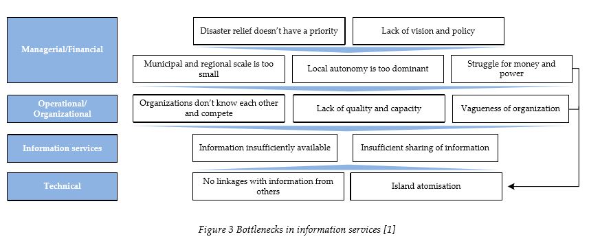
When we look at technological bottlenecks the term “others” here refers to people outside of the public safety chain. This will become an issue concerning information of others that has to be linked to the positioning information and therefore also has to be addressed. The second technological bottleneck identified by ACIR is that of island atomization. This has to do with the fact that the involved organizations implement their own systems and neglect the possibility to link them to the systems of other disciplines. This bottleneck is considered relevant because of the need to exchange positioning information during disaster relief, which is also brought forward as a bottleneck in the information services layer. The availability of information can be related to the availability of positioning information at the location of a disaster, which therefore also has to be addressed. The bottlenecks in the first two layers should also be taken into account because of their influence on the realization of the positioning platform. Solving them on the other hand is considered outside of the scope of this research. The fact that positioning information is relevant for disaster relief is motivated by using the following figure.
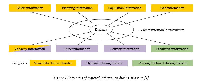
This figure shows all the categories of information which are required during disasters. The positioning platform has linkages with practically all the categories brought forward. The geoinformation for instance, which consists of routing information, object identification in risk zones and locations of temporary emergency care, can be facilitated by a positioning platform. Activity information can also be facilitated by linking it with the positions of objects and/or the operational units.
Finally it is also important to take into account the advice of the ACIR advisory panel. The advice brought forward by ACIR concerns the realization of making necessary information during disasters available and consists of three pillars. Each pillar is considered relevant concerning the realization of the positioning platform and is therefore taken into account in the design of the platform. ACIR has provided 12 recommendations (see table 21 in appendix II) which can be categorized in the following three pillars [1]:
I. Realizing uniform demand for information on the national level
II. Realizing information management and multidisciplinarity on the regional level
III. Keeping options open to take control when necessary
2.2 Existing systems
The stakeholders in this research make use of various types of technologies. Some technologies are used by all the involved organizations, but there are also stakeholders who have their own systems and the corresponding ICT strategies. This section presents descriptions of the two most relevant overlapping systems. A system is considered overlapping in this case when it is used by all the stakeholders. This is the case for the C2000 communication network and the integrated emergency control centre system (GMS). First information concerning the technological background of both systems is given, followed by a short reflection on an evaluation done on the C2000 project.
C2000 communication network
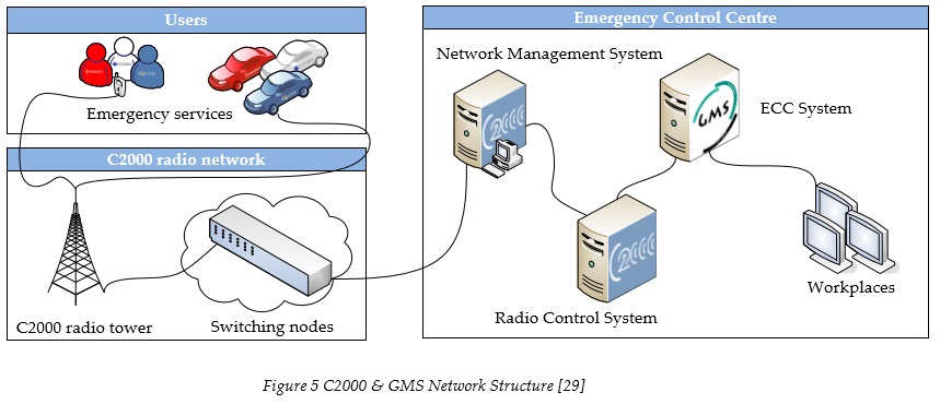
The C2000 network realized one voice communication platform for the Dutch emergency services. This network, which is closed to the general public, is based on the use of digital technology and has replaced approximately one hundred analogue networks. The preparations for this network had already started in 1993 and it took about a decade for the network to reach all the emergency services and realize national coverage of the signal [18]. The network infrastructure consists of a radio network with national coverage, network services, radio control systems and peripheral equipment. The choice was made to make use of a new technological standard called “TETRA” which is an ETSI standard published in 1995 and also endorsed by the European Radio Communications Committee (ERC) [43]. The radio network consists of radio towers with sending and receiving functionalities, switching nodes connecting the base stations with the control centres and a Network Management System. The following figure shows the different components of this network [29]. This figure also shows that the management of the network is collocated to the emergency control centres.
There is a chance that a building, which has been built by using specific construction materials, isn’t penetrable by the C2000 signal. When for example a disaster takes place at such a location, no communication via the C2000 network would be possible from inside the building. Based on a few criteria, a structure can be appointed as a Special Coverage Location (SCL). Appointing such a location as an SCL is up to the authorities. The authorities can be advised on such actions by the emergency services and can then oblige the owners of these objects to install hardware for enabling indoor C2000 coverage [29]. These locations are primarily malls, tunnels, and soccer stadiums but they can also be buildings of ministries or large office buildings. Two of the companies that can be hired to extend coverage of the C2000 network are Flash Services [33] and Zenitel [50]. They do this by using cell enhancers which is illustrated in figure 6. The relevance of SCL’s for the positioning platform can be found in the fact GPS signals show the same type of restriction. Dependant on the outcome of this research it might be possible that the same type of solution can be used to realize indoor positioning.
Integrated Emergency Control Centre System (GMS)
The integrated emergency control centre system (GMS) is meant to function as the backbone of the integrated emergency control centres. The integrated emergency control centres are emergency control centres in which control centre employees of all the emergency services are present, namely the fire brigade, ambulance care and the police. The GMS software has thus been developed in a way that it can serve every discipline. GMS structures the information brought forward by someone reporting an emergency and automates the actions that have to be taken in order to address the call. When a call comes in about an emergency the GMS software asks the Emergency Control Centre (ECC) employee certain questions. After answering these questions the software proposes a plan of approach specifically designed for that emergency. When confirmed, this plan will alert the different organizations via the C2000 communication network. Recently the choice has been made to work on a new GMS which is called NMS (Nieuw Meldkamer Systeem) [16]. The relevance of this software can be found in the fact that a positioning platform could provide a lot of advantages when it’s combined with this software. This way the ability is gained to incorporate positioning information when a plan of approach is designed. This plan of approach then takes into account aspects which are currently mostly ignored and thereby provides more efficient use of scarce resources.
C2000 project evaluation
The C2000 project gained the status of large project in 1997, which meant that from that moment on the project, would have to meet the regulatory procedures in place for such projects. One of the procedures is the fact that a final evaluation of the project has to be done in order to end the project and take away this status. The results of this evaluation were published in May of 2006 and the following learning moments and recommendations were given in the report [18]:
- This type of project should be handled with clear and consistent project methods, where all the stakeholders play their own role and have their own tasks and responsibilities. Short lines should be realized between these roles and emphasis should be put on realizing commitment.
- The project was considered a technological project and this has caused a lack of involvement of the administrative level. The reason for this can be found in the way the emergency services have been organized in the Netherlands, which is namely from a monodisciplinary perspective and the fact that the administrative level is mostly responsible for all the disciplines within the region.
- Not every discipline has its own demand organization concerning ICT, which makes it difficult to match it to the supply.
- There was no steering on the process or the results. The effects were therefore mostly unforeseen.
- The different disciplines have their own monodisciplinary budgets and ways of financing. In case of projects such as C2000, the government should hold the budget and discuss the division of the costs with the different stakeholders. This division has to be made transparent and represent the amount of added value for each discipline.
- New technologies require a flexible approach. New functionalities have to be added in the future and this can be realized by using a high level of standardization.
- The most important suppliers should have a strong relationship with the government
- It is difficult to define clear goals at the beginning of an innovative project. The status of large projects should only be assigned to such a project when there is sufficient information available to be able to define clear goals and thereby have insight in the progress made.
The same problems which were faced during the realization of the C2000 project can be faced when implementing the positioning platform. The resemblance between the two projects can be found in the fact that they both concern all the emergency service disciplines and the fact that both can be considered as innovative and large technological projects. By using the experiences gained in this project, we are able to design a more suitable platform, not only concerning the implementation, but also concerning the use of the services when the platform has become operational.
2.3 Organizational descriptions
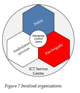
This section provides descriptions of the stakeholders which are involved in the realization of the positioning platform. This is done by looking at how they have evolved throughout the years, what their primary tasks are and the way they have organized their ICT strategy. The three organizations in the centre of figure 7 are often referred to as “the red, white and blue” and play a central role in this thesis. In august 2006, the ISC (ICT-Service Centrum Politie, Justitie en Veiligheid U.A.) was formed as the ICT supplier for the entire law enforcement and security chain. They are currently also responsible for the management of the 2000 network [36]. The integrated emergency control centre which is shown in the centre of the figure is used to coordinate the different emergency services towards emergencies.
ICT Service Centre
On the first of august 2006 the vtsPN was established (Voorziening tot samenwerking Politie Nederland). The entire police organization in the Netherlands delegated their critical IT tasks to this organization which was realized by bringing together several organizations, the ISC, CIP and the NPI. Within this group the ISC is currently responsible for the management of the C2000 network and most probably also responsible for the management of future technological platforms used by all the emergency services. The following services are currently provided by ISC [36]:
- Application development and management
- Networks (public services)
- Architecture
- Computing services
- Emergency Control Centres and mobile communication
- Security
- Workstations
- Helpdesks
- Innovation & product development
As this list shows, there are various fields in which the ICT Service Centre is operating. Most of them are provided to all the emergency services, where other services are only provided to the police. Here we can also see that most of these services also have a direct link with the positioning platform which brings to the attention that this organization should be directly involved in the realization of the platform because of their experience in this field.
Integrated Emergency Control Centre
Because of the need for a multidisciplinary approach during disasters the integrated emergency control centre has been put in place by the Dutch government. These emergency control centres consist of all the three disciplines (i.e. police, fire brigade, ambulance care) and the needed arrangements and agreements amongst them in order to react appropriately to emergencies which require a multidisciplinary approach. We do have to keep in mind that at this moment the integrated emergency control centres haven’t yet replaced all of the existing emergency control centres. The front offices of these integrated emergency control centres are currently monodisciplinary, which means that the notion of integrated practically only concerns the physical location of these control centres and the arrangements mentioned earlier. There are some thoughts on realizing a multidisciplinary front office based on the following arguments [24]:
- Each demand has to accompanied by the shortest path towards a qualitative solution
- The public mostly doesn’t care which emergency service addresses their emergency, as long as they receive the support they need
- Standard problems can be solved by using standard solutions
- In order to get fast and adequate help an optimal division has to be made between the front and the back office
- The up and down scaling has to be realized at the level of the safety regions
- The public, client, patient is central
In this case the mono-disciplinary back offices make use of standardized processes and when a disaster happens a multi-disciplinary control centre can be used. Figure 38 shown in appendix IV is a sketch of a multi-disciplinary emergency control centre information system. This vision of having a standardized multidisciplinary front office system reflects the need to have a “virtual” system which can be used in different regions without having to make any modifications [24].
Fire brigade
Fire fighting in the Netherlands has by tradition been a task for the municipal councils. A total of 475 fire brigades exist, with the strength of the brigade relative to the size of the municipality. The main tasks of the fire brigade in the Netherlands were legally defined in 1985 as follows:
The fire brigade has the aim to prevent, limit and fight fire, limit the danger of fire, prevent and limit all the accidents with fire and everything that relates to it: limit and fight the danger of fire for humans and animals at accidents other than fire and limit and fight disasters.
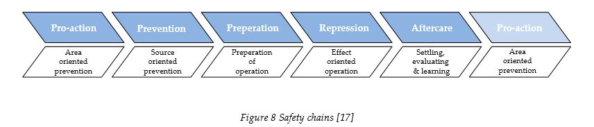
The fire brigade has addressed this objective by constructing several safety chains [17]. A pro-action chain concerns the involvement of the fire brigade with the planning for the area covered by the municipality in order to limit risks and realize effective operation. Within the prevention chain the fire brigade grants permits on behalf of the municipal council and provides advice concerning protection against fires. Exercising the approach to different types of fires is considered as the preparation chain and the actual fire fighting is represented by the repression chain. The entire chain is concluded by evaluating the chains mentioned above within the aftercare chain and using this information as input in the first chain. When we look at these chains we have to conclude that the last three chains are the only chains that can be directly linked with positioning technologies. The other chains show more opportunities when combined with GIS (Geographical Information Systems) and could be thus linked with positioning technologies. The different safety chains are shown in the following figure.
Next to the municipal fire brigade, there is also a regional fire brigade which performs the following tasks:
- Establishing and maintaining the regional fire brigade alarm centre.
- Acquiring and managing communal material
- Preparing and coordinating the control of disasters and large accidents
- Warning the public by using the siren-net
- Exploring hazardous material and performing disinfestations
- Advising the municipal board on the terrain of fire protection
- Advising the municipal board on the terrain of fire fighting
- Organizing large-scale exercises
- Organizing the educational programme
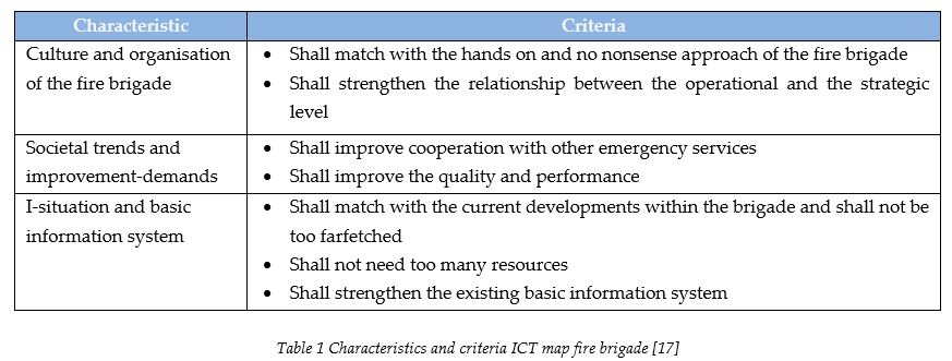
To do this effectively a lot of coordination with the municipal fire brigades is needed. The quality of the information needed for this coordination is dependent on the quality of the information services within the municipalities. This information is rather dynamic and concerns officials, buildings, infrastructures, road constructions, building plans and so on. With the instalment of the NVBR (Nederlandse Vereniging voor Brandweerzorg en Rampenbestrijding) in 2002, the first step was taken for cooperation between the different fire brigades. The vision of the NVBR on information supply inspired the design of an ICT-opportunity map for the Dutch fire brigades. The vision was that information should be reused and exchanged, cooperation with other emergency services should be stimulated and a demand-driven organization concerning ICT should be realized. A list of 35 ICT innovation opportunities was also made up (see table 22 in appendix V). These opportunities were evaluated by looking at a set of criteria based on the characteristics of the fire brigade in the Netherlands. Some of the feasible opportunities are only possible if a positioning technology is implemented where others show possibilities for synergy when they are combined with this technology [17]. The following table shows the defined characteristics and the criteria which were used in this project:
Ambulance care
There are in total around 650 ambulances within the Netherlands spread out over 195 locations. These ambulances are coordinated from 24 different emergency control centres. An ambulance service is public or privately organized and requires a licence which is given dependant on results of benchmarking on performance and quality standards every three years. There are several types of emergencies to which ambulances react. These are shown in the following figure:
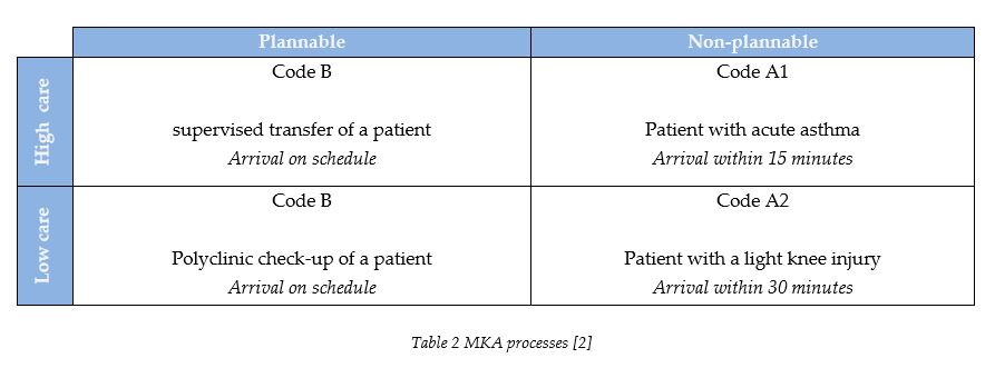
Ambulance care in the Netherlands can be categorized into two types of services, the traditional ambulance services and the GHOR (Geneeskundige Hulp bij Ongevallen en Rampen). GHOR stands for medical assistance at accidents or disasters. In reality, the GHOR is the same type of service, but only differs because of the scale, the prioritisation and the cooperation with other emergency services. The ambulance sector in the Netherlands has been reorganized severely in the past few years and is on the verge of implementing new regulations (Wet Ambulancezorg). These new regulations are enforcing the use of integrated emergency control centres, but also restrict each safety region to only having either commercial or public ambulance services [2]. The part of the integrated emergency control centre that coordinates the ambulance services is called the MKA (Meldkamer Ambulancezorg) which has been set up because of the specific needs for handling emergency calls that need medical attention. AZN (AmbulanceZorg Nederland) came with a policy paper in 2006 on the use of dynamic ambulance management [2]. This has been the result of the Ambunet-project which was finished in 2005. This project realised real-time tracking of all the ambulances from different regions on the screen used by the MKA employees. This way it was possible to direct an ambulance to a patient or scene but from different regions than those formally assigned to that specific location. The needed guidelines were implemented soon after, but only envisioned emergency responses with the urgency level A1 (see table 2).
Next to some sector specific technological developments, such as Rapid Fluid Administration or the implementation of more AED’s (Automatic External Defibrillators) the idea of having Electronic Patient Forms has emerged in the ambulance care sector. There is a lot of interest in automatic patient data transmission and collection to and from a central database [54]. The Ministry of Interior Affairs and Kingdom Relations approaches ambulance care as being part of the public safety sector where their own Ministry (Health, Welfare and Sport) considers them as being part of the care taking sector. The requirements from these two sectors differ which makes it difficult for the ambulance care to find a suitable ICT policy. Next to this, some developments can be seen which influence the way ICT has to be fitted within the organisation [3], these are shown in table 23 in appendix VI. Some of the points shown in this table illustrate the tendency of the ambulance care to look at the developments from their own perspective rather than take part in a more multidisciplinary approach concerning information systems and ICT services. This can be seen in the fact that they want to focus more on their own responsibilities rather than on the common responsibilities within the upcoming safety regions and the fact that they are decentralizing ICT support and advice.
Police
The police in the Netherlands are organised in 25 regions and a National Police Services Agency (KLPD) which is occasionally called the 26th region. The size of the regional police is based on the population size, crime levels and the building density. The police are also divided into a number of districts or divisions which perform police duties within their designated geographical region. The KLPD on the other hand only commits itself to more serious crimes, violations of environmental laws and disaster relief on the national level. The Minister of Interior Affairs and Kingdom Relations is responsible for all the Dutch police. This Ministry is also the holder of the budget. In general the tasks of the police are to patrol the streets and other public spaces, maintain public order, investigate criminal offences and provide assistance during emergencies [41].
The Dutch police have given a proposal with their vision on the development of police information management and ICT in the upcoming years [21]. The police have the aim to internationalize the battle against crime and the information that is needed is mostly gathered regionally because of the way the organisation is structured. For this to work attention has to be paid to the sharing of information between these regional clusters. This does on the other hand ask for a careful approach concerning the privacy and the security of the system. Their vision also emphasized the need for Service Oriented Architectures (SOA) and the fact that the use of generic portals can increase cooperation between different sections of the organisation. Another important aspect was considered to be the personalisation of information. The police work in different environments and information has to be presented to them in the most appropriate way. Thy also have a lot of legacy systems dating back for example more than two decades. A lot of knowledge has been invested into these systems and this has to be taken into account when implementing new functionalities or other systems. This part also creates most of the complexity during change procedures. At this moment, the operational information is essentially stored regionally in one of three primary systems or on one of the two detection systems. The goal is to integrate the existing ICT-components into one architecture and realize implementation and use of the system on a national level by the year 2011. Concerning the exchange of information with other parties, it is concluded that cooperation on the strategic level is essential and that a lot of attention also has to be paid to the privacy and security of the data reaching other parties [21].
2.4 Reflection on the background
This chapter has provided some background information concerning the different stakeholders by looking at some important aspects. The first section paid attention to interdisciplinary information systems, based on the findings of the ACIR advisory panel. This section stressed the importance of having information and sharing this information, especially during disasters. These disasters have happened in the past and most likely also occur in the future. ACIR brought forward that the required information during disasters is currently unavailable and no information is shared between the different disciplines. The causes for this have been identified within several bottlenecks, which have to be addressed at the managerial, financial and organizational level. This section also brought to the attention that positioning information can be considered as an important asset during disasters, which is also why we consider it important to take notice of the recommendations this advisory panel has given (see table 21 in appendix II).
We have also paid attention to the existing C2000 network and GMS. Both these systems are used by all the emergency services, which has motivated us to look at them more specifically. The special coverage location policy used for extending the coverage of the C2000 TETRA based signal showed possibilities for using a similar type of approach concerning the unavailability of the GPS signals in indoor environments. The evaluation done on the C2000 projects also brought to our attention the resemblances between the C2000 project and the positioning platform. In order to design a suitable positioning platform, we have to take into account the required integrated approach brought forward by ACIR in the first part of this chapter, but we also have to take into account the many differences which have caused the problems presented in the evaluation of the C2000 projects.
The differences between the stakeholders have caused problems concerning the realization of the C2000 projects and this has also become clear during the literature study on their backgrounds. This can be seen in the different ways they have evolved, the different tasks they have to fulfil and the different ministries to whom they belong. It also concerns us that the first two stakeholders (i.e. ISC and the integrated ECC) are currently playing a multidisciplinary role, where the other organizations are operating in a monodisciplinary fashion. Although some similarities exist concerning their visions of the future of ICT infrastructures, the steps they are willing to take to get there differ significantly and have to be taken into account when new ICT infrastructures with a multidisciplinary character are designed, implemented and used.
3 Interviews
The previous chapter presented some background information, but in order to acquire more specific conditions and requirements we had to conduct interviews with key people from the stakeholders. This chapter provides the conditions and requirements concerning the positioning platform, brought forward by the respondents during these interviews. First a description is given on the chosen interview method followed by a part listing the most important requirements with their respective motivations. This section is written from the perspective of the respondents and therefore results in having some inconsistent argumentations. The third section uses the information given in the second section and analyzes the way these stakeholders relate to each other. The last section describes how the information is categorized and used to determine the variables which are used in the following two research phases.
3.1 Interview method
The results from the literature study were presented in the previous chapter. This chapter provides the results from the second and last method used for the first phase of the research, namely the interviews. Before choosing respondents a viewpoint on organizations had to be chosen which in this case is based on the organizational configurations of Mintzberg [19]. According to Mintzberg, the following six parts exist in each organization:
- Strategic Apex (top management)
- Middle line (middle management)
- Operating core (operations, operational processes)
- Technostructure (analysts that design systems, processes etc.)
- Support staff (support outside of operating workflow)
- Ideology (halo of beliefs and traditions; norms, values, culture)
Due to the limited time frame of this research, we had to make a choice between these different organizational parts. When we look at these categories from the perspective of this research and its objective, the most interesting category is that of the middle line or middle management. It is expected that they are still in touch with the operational processes, but also have knowledge of the existing institutions. This research has also a lot of technological elements and this has been taken into account by focussing the attention on middle management with a link to innovation which has resulted in having interviews with mostly people responsible for the innovation policy.
The respondents were chosen based on the findings of the literature study which was done and described in the previous chapter. After providing LogicaCMG the needed description of the types of people that had to be interviewed, a list of names was given back with the corresponding contact details. Some of these respondents were then contacted directly, where others were previously informed by LogicaCMG. When needed, the respondents were given the research proposal in order to create understanding concerning the scope and topic of the research. The reason for involving LogicaCMG in determining the most appropriate respondents lies in the fact that they have a lot of experience in this field. The people responsible for establishing the contacts have had experience with the C2000 project and therefore knew who would be most appropriate due to the similarities of the C2000 project with the positioning platform (see table 3, respondent 5 & 6). We do have to mention that not every respondent was brought forward by LogicaCMG. Some were contacted by calling the respective organizations and providing the needed information in order to be able to determine who would be most appropriate. The following table doesn’t provide the names of the respondents due to privacy issues, but it does mention the different involved organizations and the relevance of the involvement of the respondents concerning the objective of this research.

3.2 Interview results
This section provides a list of the most important requirements with their corresponding motivations. First the ICT Service Centre’s requirements are given, followed by the Integrated Emergency Control Centre, the fire brigade, the ambulance care and the police. The requirements corresponding to the ambulance care and the police are based on the input given by two respondents and therefore cover different abstraction levels.
ICT Service Centre
C2000 signal could be used to determine a position, but this would need additional hardware: There is a possibility to use the C2000 signal to enable indoor and outdoor positioning. The accuracy is dependent on the location and the corresponding density of C2000 towers. It is impossible to guarantee availability of the signal indoors, because some buildings are practically impenetrable. The signal is on the other hand already mostly available indoors and can be compared to the availability of the GSM signal. In order to be able to provide positioning with the C2000 signal, reference stations do have to be implemented.
C2000 network is ill suited as a data network for exchanging positioning data: A research on the limitations of the C2000 network has leaded the ISC to believe that this network isn’t suitable to track all the handhelds and vehicles. There are two ways to transfer positioning data over the network. One way is by sending it in IP packages. These IP based packages then use the same capacity which is currently available for voice communication. This can severely affect the quality of the voice communication. Another way of transferring this data is by using the available control channel. Every C2000 tower has a control channel which is used for the signalling information. By using this control channel, there will be no need for IP based packages, which traditionally also use more space because of the need for overhead. The control channel on the other hand has one major disadvantage which is the fact that it isn’t scalable. The suppliers of the infrastructure have already been asked to implement a second control channel, but no actions have yet been taken because of the need for fundamental changes to the existing infrastructure. When using this control channel for positioning information, it was realized that when too much information is sent, a significant delay occurs in the setup of the voice communication channel. Appendix III illustrates and describes how GPS positioning can be imbedded within the C2000 network, but this solution can only facilitate the exchange of a limited amount of positioning data.
The positioning platform should be available when & where commercial networks aren’t: Technology comes hand in hand with limitations. C2000 takes this into account by using network management tools to reroute messages and make use of the network infrastructure more efficiently. When this isn’t enough a mobile solution can be used which consists of three vehicles with C2000 towers mounted on top of them in order to enable communication when the network fails at a specific location. Because a lot of the network failures still occur without us knowing it beforehand, the suitability for mobile solutions is rather limited. A network should thus be designed with the knowledge that it has to provide the needed capacity at all times. Commercial based networks have the tendency to fail when there is too much demand for their services. The advantage of the closed C2000 network is that it is able to function during high demand. Other factors that have to be taken into account are the security and the price of using the network. At this moment ISC already provides access to a secured part of commercial networks (i.e. KPN and Vodafone) to the emergency services when needed but these networks aren’t used for critical services. A service is considered critical when it has become a necessary asset during operations.
Connections to the positioning platform should be limited because of sensitive data: The C2000 network is primarily only available to people working for the emergency services. Other organisations are allowed access only after they are brought forward by someone from within the public safety chain and after an assessment made by the Ministry of Interior Affairs and Kingdom Relations. The availability of semi-open channels isn’t considered a problem, as long as the organisations using the network take this into consideration and act accordingly. The ISC’s recommends for example not providing the fire brigade information about the whereabouts of the police. This is something that has to be prevented technologically, but also explicit organisational guidelines need to be designed according to these specific needs.
The developments in neighbouring countries should be taken into account for future cooperation: At this moment the availability of the C2000 signal has been increased in order to provide coverage across the border. It is also possible to communicate with neighbouring emergency services by connecting to their TETRA based communication networks. Concerning the sharing of information, decisions still have to be made. Rolling out a data network is one of the things currently in debate within the public safety sector.
Integrated Emergency Control Centre
A phased approach using the C2000 network is only an option when used as a backup service: The emergency control centre is aware of the ability to use the existing C2000 network for the exchange of positioning data and also of its limits. Next to the fact that the emergency control centre is already using commercial positioning services which offer a high update frequency, a lot of them also have terminals inside vehicles which require data exchange in general. This limits the willingness to adapt to a phased approach for the exchange of positioning data through the C2000 network. This phased approach would evidently mean that no real data exchange would take place and only low update frequency based positioning services would be able at the beginning. In order to get enough ground for such a phased approach, it would have to coexist next to other services and perform a backup function of the existing initiatives.
Commercial services have usability issues and are rather costly: There are several ways of establishing a data connection between vehicles and the emergency control centre, but they are all commercial and a standard hasn’t been chosen. Unfortunately the usability is rather bad. It is possible to make them work, but the amount of manual interactions needed to set up the connection with the needed amount of security and authentication, limits the usability of the services where information sent though a network such as C2000 is secured automatically.
Using one platform provides advantages in securing sensitive data and usability of the service: The ideal solution would consist of vehicles automatically connecting to a data network and the Emergency Control Centre System. The connection of an emergency call to a vehicle and accepting the emergency call by the vehicle operator would then be the only manual operations needed. Concerning the exchange of data a huge advantage can be gained by storing the data centrally and only visualizing it on handhelds and terminals. This would mean that in case of stolen equipment, only an interface is stolen and not the underlying information layer. This visualization functionality should replace the far more vulnerable data storage functionality currently used by most organisations working with these types of services.
The positioning platform should take into account the path that has been chosen by control centres: Most of the Geographical Information Systems in the public safety sector come from two companies. The police have on the other hand also started to develop their own GIS, which is called Sherpa. This project was initiated before the emergency control centres were being integrated. The integrated emergency control centres have chosen a path, which also covered the use of GIS and other systems. Getting Sherpa inside the emergency control centres is also dependent on its ability to connect with systems of other emergency services. These existing connections are partly realized commercially, which might be a problem when a public service is trying to take over some of their functionalities.
The longer it takes to realize a positioning platform, the more diversity is created: Some organisations are hesitant towards choosing a service and signing contracts not knowing which service is best suited or has the potential of becoming the public safety standard. The emergency control centre is therefore rather optimistic when it comes to new types of multidisciplinary platforms. The costs for using the commercial services are such that the emergency control centre expects that the only reasonable solution can come from a government owned platform. Another problem is the lack of management of innovation. Emergency control centres often experiment with innovative services which another control centre has already fully developed.
Diversity in services is a side effect of a bottom-up approach which is strongly required: The emergency control centres consider innovation as something some people like to commit themselves to. These people are currently dispersed heterogeneously across the different regions, which results in innovative and less innovative regions. Bringing these people together at the ISC would cause them to lose touch with the field. Although the Netherlands can be considered as a small country, the regions have very different characteristics. Some cities are faced with a great deal of tourists, where others cover a large geographical area and have to cope with a less amount of vehicles because of their relative small community.
An integrated approach is needed for homogeneity of services and economies of scale: The wish exists to organise the public safety domain more centrally, especially because of the ability to roll out services more homogeneously and create economies of scale. Some organisations are less willing to operate under the wing of a parent organisation, but this should be less problematic when the safety regions are in place.
Fire brigade
The realization of a positioning platform shouldn’t take too long because it is needed right away: The fire brigades cooperate on some level, but mostly have their own ICT strategy. They also consider the ISC to be a police oriented organisation. The general opinion is that this orientation doesn’t fit with the requirements brought forward by the fire brigade. When fire brigades see technological developments, they don’t see why they should wait until an implementation has been designed that fits all the emergency services. The fire brigades rather implement ICT solutions themselves and involve other brigades within their own region.
Realizing one platform poses threats but does fit with the need for integration: The fire brigades do see the importance of having a top-down approach concerning some technological innovations. They acknowledge the benefits of having the C2000 network for all the emergency services, but also claim that integrating networks provides a pitfall. They claim that specific information should only be accessible to people who currently need this information and that a system should fit with the institutions currently in place. Physically integrating systems does on the other hand comply with the low tolerance for delays during operations and calibrating and setting up equipment should be avoided as much as possible. The failure of the system can mean that everything fails, but on the other hand a lot of advantages can be gained because of the decreased amount of required training. The fire brigade considers the regional scale, as the most suitable scale for ICT implementations.
IT solutions need to work immediately, failure is not an option: Technology should be as reliable as possible. The general idea is that if something fails twice, it won’t be used anymore and attention has to be paid that there is enough support for using a new ICT implementation. This can be done by paying attention to the needs. If this doesn’t happen, new technologies will not be used. Only the fire brigade officer at the location and the team coordinator should have access to positioning information.
The platform should allow specific requirements to be met: It is important to use open standards because requirements might change in the future. There have been some bad experiences with C2000 handhelds. This is for example the case concerning the currently limited ability to establish a direct mode (DMO) connection. DMO means that handhelds are able to directly communicate with surrounding handhelds without the need for C2000 towers. This has been brought forward, but the handheld manufacturers refuse to address them, because they weren’t mentioned in the original specifications which by now date back more than a decade.
The step towards indoor positioning hasn’t yet been taken but it is being evaluated: Most of the situations which require action by the fire brigade occur within buildings. Large buildings offer more potential for positioning services. The question therefore has to be asked whether to use such technologies all the time or only in specific situations. By using them unnecessarily, less support can be expected and when it isn’t used enough, it won’t be used when it does provide advantages. Another technology that can provide advantages when combined with a positioning technology is telemetrics. At this moment a lot of information is generated by the equipment mounted on the fire fighter’s suit, such as (infrared) video, the amount of available oxygen and the external temperature. A way path can be calculated if the position of a fire fighter is known and therefore a more reliable measure can be used to make sure that the oxygen doesn’t run out. Creating an attack plan might be the next step, which eventually might lead to the realization of a logistic system which can be used for the operational processes.
A financial plan has to be made concerning the instalment of hardware for indoor positioning: In the case of indoor positioning implementation of hardware inside the buildings might be needed, next to the fact that building maps can get outdated because of changes done to the interior of the building. Even when services things are able to increase the safety to a high degree, it is rather difficult to stimulate people to invest in such measures when they weren’t mentioned in the allready given permits.
The need for multidisciplinary information services during disasters is exaggerated: Large scale disasters demand a lot of small scale operations. Decisions made by the officer at the location are mostly based on experiences which can be considered as tacit knowledge. Even though scenario analysis is used heavily by the emergency services, in reality each disaster can only be faced by combining different scenario approaches. The fire brigade does have a leading role within the first phase of disaster relief, but this has mostly to do with the fact that the fire brigade can scale up more rapidly than other emergency services. Communication between the different emergency services only occurs on a high level according to the chain of command. Sharing multidisciplinary information is also considered to be relevant to only a few people at the location of a disaster.
Ambulance care
ISC might be taken out of the Ambunet equation: The ambulance care AVLS currently in use by all the ambulance services in the Netherlands is called Ambunet. At this moment Ambunet has a contract with ISC. ISC is the provider of the communication lines, which are also used by the police and fire brigades. These communication lines are secured parts of commercial Networks. Ambulance care Netherlands is considering signing a contract with a commercial party without the interference of ISC. ISC is still seen as a being part of the police even though they have brought forward that they serve a multidisciplinary purpose. Whether this is in fact the case or not is something to be seen during the negotiations concerning the Ambunet contract.
Ambunet has to stay because of future requirements: The police have a lot more demands when it comes to securing data. Ambulance care has the need to link their systems with systems used by general practitioners and that could become problematic when the police are part of the network. The only way to commit the ambulance care to a multidisciplinary platform for positioning would be by providing them more, or the same but at a lower price.
It might not be possible to manage one positioning platform for all the disciplines: The advantage of having all the emergency services connect their systems and use one platform for positioning services is shared, but the provider of such a platform should have to be able to provide multidisciplinary services and whether that will happen is something that still is debated.
Ambunet could coexist next to other positioning platforms: The fact that a national positioning platform could result in competition with Ambunet is something that is disregarded, because then it would be more interesting to create two different platforms. A platform for the police and the fire brigade and another platform for the ambulance care. Then these systems can be managed by these organisations independently and only parties which are considered reliable or safe are allowed to go through a secured link made between them.
Practically any commercial organization can provide the network, as long as guarantees are given: It is not the aim to have Ambunet function as a commercial AVLS for all the emergency services. The future of Ambunet is seen as a network which can be used to exchange more than positioning data alone. Only the exchange of data is done via a commercial network, the hardware is owned by the ambulance care and in case a provider refuses to sign a new contract it is fairly simple to contract a new party.
The need for a fourth domain isn’t recognized: The national ambulance emergency control centre (i.e. fourth domain) is something the Ministry of Health, Welfare and Sport have initiated. The sector doesn’t see the added value in having such a fourth domain. Because of this construction the fourth domain is trying to get more formal functions. This has resulted in them already having some core functionalities.
The budget is limited because we’re not part of the same Ministry: The main difference between the Ministry of Interior Affairs and Kingdom Relations and the Ministry of Health, Welfare and Sport is the budget which is much larger for the former. The ambulance care has brought forward that they can’t keep up with the initiatives of this demanding ministry.
We have experience with commercial organisations and have learnt to trust them: Ambulance care consists of public and privately owned ambulance services. Therefore there is no real fear of having to deal with commercial parties. They have even seen that commercial organisations are faster, better and cheaper than government owned networks.
Ambunet has become critical, but it is unclear what to expect from the network during disasters: Services such as positioning can become critical at some point in time. It’s up to the regions to choose between different data networks. It is possible that these networks fail, but because of the rarity of large scale disasters more attention is paid to regular operations.
Sherpanet is as a platform which doesn’t comply with our requirements: Sherpanet, the GIS platform currently being developed by the police, doesn’t comply with the requirements of the ambulance care. Ambulance care Netherlands did have trouble getting all the ambulance care regions to commit themselves to their initiatives, but they are on the verge of achieving this nationally.
Integration of emergency control centres also comes with some risks: Recently a documentary was shown on Dutch television which raised some concern. It brought forward that a significant amount of the ambulance vehicles isn’t able to reach a patient within 15 minutes [38]. When asked for a response, attention was raised concerning the existence of integrated emergency control centres. The emergency control centre was in this case integrated, where in other regions it is kept as a part of the regional ambulance care organisation (RAV). The RAV model is preferred by the ambulance care Netherlands and the Ministry of Health, Welfare and Sport. The integrated emergency control centre is part of the vision of the Ministry of Interior Affairs and Kingdom Relations. The problem isn’t the fact that these organisations are put together into one building. The problem lies in the fact that some decisions have to be approved by other organisations.
The new ambulance care law provides possibilities for integration and innovation: The new law for ambulance care which is currently being assessed by the government, forces regions to have one type of ambulance care, which is allowed to be either commercial or public. This would force the existing services in one region to merge, buy each other out or compete for the license.
Police
Positioning handhelds is promising but requires a more accurate positioning technology: The positioning method used currently by the police is that of GPS which has its downsides even when the signal is available. One of the problems is its accuracy. When we look at the positioning of a handheld instead of a vehicle, more accuracy is needed.
Indoor positioning sounds promising, but it would only be needed in very specific situations: At this moment, everyone keeps on updating their position verbally. Knowing the whereabouts of other officers within a building can take away a lot of this communication. When the positions are shown on a PDA held by a local coordinator, it becomes possible to strategically direct the officers.
A positioning platform would especially be useful if the information is used automatically: A nice example of the type of efficiencies positioning technologies can provide for the police was found in the United States in the town of Milpitas (CA). This town has chosen to implement a roaming wireless service using WiFi and UMTS networks. When the emergency control centre employee enters the needed information, the computer sends a message to the nearest vehicle that complies to the requirements. In the Netherlands, the nearest vehicle is searched by looking at a map. The Milpitas police corps has brought forward that their approach can create a 20 to 30 percent saving of time.
New technologies can have a lot of benefits, but the usability remains very important: The majority of the police officers are middle-aged or older. It is rather difficult to train all the officers to use new types of services. The most important thing for the police would be to take away tasks instead of adding more.
When positioning services become critical, commercial organizations are not an option: ISC has chosen to use commercial networks for the mobile exchange of data. These networks can be used by using SIM cards provided by the ISC and additional authentication codes. The information then goes through a secured tunnel within the public network. Using these kinds of networks is considered as an option when the services going through them aren’t critical. In order to come up with critical services, the network should be comparable to the C2000 network.
A positioning platform should use a roaming principle when a national public network is lacking: The police consider public networks such as WiFi as an option for the future, as long as they have a secure connection. Until a suitable national network is implemented, the preference goes to using a roaming principle, which would mean that the handheld would screen available networks and choose the most suitable one.
Special peripheral equipment is needed and can be achieved by a larger demand organisation: Commercial parties are needed to provide the handhelds. Unfortunately the market hasn’t yet realized the potential for special public safety handhelds. In order to stimulate the market to come up with specialized services and products, cooperation is needed within the entire sector or maybe even on an international level.
The ISC should be more involved in developing a positioning platform for the emergency services: The main problem concerning C2000 is considered the lack of vision towards the future. This is a common problem when it comes to innovation because at some point boundary conditions have to be set, but this also forces you to think more ahead and work with a wider scope.
The exchange of positioning information should be allowed, but only when it’s needed: Exchanging data when there is no disaster should be handled with a lot of care because of the sensitiveness of the information. The main barrier to designing innovative services that take this into account is the lack of having an appropriate technological platform.
Cooperation between the disciplines can be realized strategically: The police are organized from a higher level than the other disciplines, because autonomy practically starts at the regional level. The chances for cooperation should be found within multidisciplinary operations during disasters and the use of safety regions. Concerning GIS and disaster relief, an important role can be played by the fire brigades because of their leading role during disasters. The police have the feeling that the need for cooperation is most of the time realized too late, which is off course very unfortunate.
3.3 Stakeholders and their dedication
The information given in the second chapter and the previous section can be used to analyze the different stakeholders. The research has chosen the perspective of all the stakeholders by aiming at designing a platform which uses an integrated approach, influenced by the report of the ACIR advisory panel, but also by taking into account the differences between the stakeholders which in certain occasions force us to design a less integrated solution. The following table takes on the perspective of the integrated approach supported by the ACIR advisory panel and compares the different stakeholders concerning their dedication towards this vision. Another variable which is used is the degree to which a stakeholder is critical to realize this vision, but because of this vision incorporating all the stakeholders the choice has been made to consider them all critical. The following table provides the motivations.
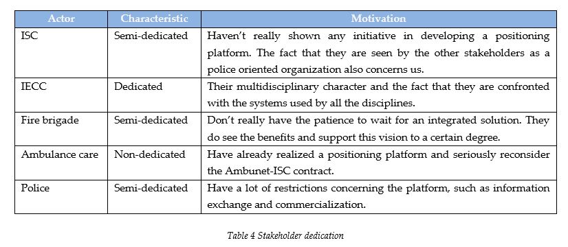
3.4 Constructing variables
The conditions and requirements are determined by looking at the background information provided in the second chapter and the input given by the respondents which was presented in the second section of this chapter. By doing this the first research phase is concluded and thereby provides the needed information for the following phase. This section describes how the conditions and requirements have been categorized and how different variables, which are needed in the following phase, are constructed. The introduction of this thesis presented the research questions and the methodological framework. This framework illustrated that the products of the first phase were the following (see figure 1):
- Technological conditions & requirements
- Organizational conditions & requirements
These conditions and requirements have been determined by looking at the information which was acquired by performing the literature study and by conducting the interviews. First all of the conditions and requirements were put in a table with their corresponding source. These sources reflect the different sections in this and the previous chapter and are the following: ACIR, Existing systems, ICT Service Centre, Integrated Emergency Control Centre, Fire brigade, Ambulance care and the Police. After analyzing all these conditions and requirements the table was first split into two tables representing technological and organizational aspects. After this first the table with the technological items was analysed in search for a consistent pattern. The items were then grouped in such a way that each group represented the same technological aspect. This was also done for the table with the organizational items. In order to determine which label each group would have to be given the role of the following research phase had to be taken into account. The second research phase consists of providing technological options and organizational arrangement options. These options would have to be explored by performing a literature study and would thereby require suitable variables representing the different categories of options.
The figure shown below illustrates the pattern which was found in the table with the technological conditions & requirements. Two main technological aspects were recognized. GPS positioning was considered early on to be a problem concerning indoor positioning. This with many other conditions and requirements concerning the determination of a position brought to the attention the fact that the positioning technology was a reoccurring aspect. Next to this the absence of a data network was realized. The positioning data has to be sent from a mobile location to emergency services and emergency control centres, which required a data network. It was noticed that the other groups all had a direct relation to one or both these two aspects.

The choice was made to use all of these aspects and label them as variables which could be addressed in the following research phase. Unfortunately such a pattern wasn’t found in the table with the organizational conditions and requirements, but we were nonetheless able to determine a list of variables which represented the different groups of items. The following two tables present both the technological as the organizational variables found. The entire list of conditions and requirements are presented in appendix VII because they present information which already has been given earlier in the thesis.
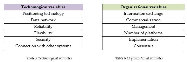
The first technological variable is that of the positioning technology. These are technologies which can be used to determine a position. The second variable is the data network. This variable addresses the network which is needed to exchange the positioning information. This is followed by the reliability variable, which addresses the reliability of both the positioning technology as the data network. The flexibility variable addresses the possibility to adapt both the positioning technology as the data network to existing or new needs. The security variable also addresses both the positioning technology as the data network. The connection with other systems variable addresses the way the information is to be exchanged with systems of organizations outside of the public safety sector.
The organizational variables start out with the information exchange variable, which addresses the information that is to be exchanged between the different emergency services. The commercialization variable addresses the amount of dependency on commercial parties which is allowed. The management variable concerns the management of the data networks. The number of platforms variable concerns the different visions of the stakeholders on how many platforms should be realized. The implementation of the positioning platform is addressed by the implementation variable and consensus addresses strategic options for realizing commitment among the different stakeholders concerning the need for having a positioning platform.
3.5 Research questions I & II
After structuring all the conditions and requirements, we now are able to address the first two research questions:
I. What are the technological conditions and requirements for this positioning platform?
II. What are the organizational conditions and requirements for this positioning platform?
From a technological point of view, there are two main elements that have to be addressed when designing the positioning platform. These are the positioning technology and the data network. The other technological requirements and conditions are directly related to either one or both these aspects. The organizational requirements can’t really be categorized in this manner, but in order to be able to provide a suitable design, these conditions and requirements have to be met as much as possible.
There are some observations we have to look into concerning the outcome of this phase. The financial aspect has gotten limited attention. It is addressed by the different organizations in terms of realizing a public or commercial network, but the underlying question about who should eventually pay and for what, didn’t really get any attention. This might have to do with the fact that this research didn’t present a solution but rather had the aim to determine to which conditions and requirements the solution had to commit. Without having the design of the platform a priori it becomes a problem to determine how costs should be delegated. This doesn’t mean that this isn’t important and it still has to be taken into account in the design.
This phase of the research did show that there are a lot of conditions and requirements which have to be met. Both the technological as the organizational conditions and requirements present conflicts, which are difficult to address. It has also been noticed that these organizations different significantly and also consider themselves to be different from region to region or even between different local institutions of the same discipline. It was also noticed that the different stakeholders have already started some initiatives concerning the use of positioning services, but the current phases of these initiatives also differ significantly, with only the ambulance care having realized a national positioning platform.
4 Technological options
Section 3.4 provided two tables with variables addressing technological and organizational conditions and requirements. This chapter addresses the technological variables by first looking into the options and then by assessing the options based on different criteria. The variables are addressed in the same order as they were presented in table 5.
4.1 Positioning technology
This section will discuss possible positioning technologies. The technologies are reviewed by looking at different aspects and the information is gathered by conducting a literature study. Appendix IX provides descriptions of the methods these technologies use or can use in order to create more understanding of the material presented.
GPS positioning
What the GPS satellites transmit can be generalized in two categories, ranging signals and the navigation messages. The navigation message which is also called ephemeris is used to calculate the position of the satellites and contains orbital information. The ranging signals can be used to measure the distance to the satellites. By using a CDMA technique (Code Division Multiple Access) GPS receivers are able to recognize multiple satellites on the same frequency. The time delay is measured between the time of transmission and the time of reception. The speed at which the signals travel is known and it is therefore possible to calculate a position by using the principle of trilateration (see appendix IX). Modern electronics are able to measure the difference between the time of transmission and the time of reception within about 1% of a bit time, which represents an error of about 3 meters. By using the P-code, which is a different signal, an accuracy of about 30 centimetres is possible, but this signal is for military purposes only.
Next to this there is also the User Equivalent Range Errors (UERE). These are ionospheric effects, ephemeris errors, satellite clock errors, multipath distortion, tropospheric effects and numerical errors. When all these errors are taken into account an autonomous civilian GPS is accurate up to 15 meters horizontally. The figure on the right shows these errors. The signals in the case of this figure are received by using a static GPS receiver and as the figure shows, the height is most inaccurate.
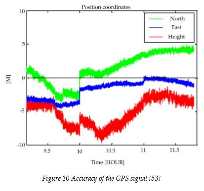
Assisted GPS
A data network can provide mobile GPS enabled handhelds additional information. This would most likely be information about visible satellites, a reference time and Doppler shifts. This information improves the sensitivity of the GPS receiver, enables faster acquisition times and reduces the receiver power consumption [13].
GPS accuracy problems and improvements
Augmentation is a method to improve the accuracy and the integrity of GPS based positioning by incorporating additional information. Two types of augmentation systems are distinguished: Satellite Based and Ground-Based augmentation systems. The satellite based augmentation system uses satellite-broadcast messages where the ground based augmentation systems make use of terrestrial radio messages. The information sent can be put in three different categories:
- Sources of error (e.g. clock drift, ephemeris, or ionospheric delay)
- Direct measurement (i.e. looking at positioning error in the past)
- Vehicle information (e.g. incorporating dead reckoning and inertial navigation systems (see appendix IX)
Galileo is expected to provide four services namely the Open Service (OS), the Commercial Service (CS) the Public Regulated Service (PRS) and the safety of Life Service (SoL) [31]. The most obvious choice for the positioning platform here would be the Public Regulated Service (PRS). This service is targeted at security authorities (e.g. police, military etc.) and is therefore to a certain degree protected against jamming and problems should be able to be detected within 10 seconds. The problem here is that the accuracy of PRS is expected to be the same as OS, which has an accuracy of less than 15 m horizontally and less than 35 m vertically. So, when this service is chosen the positioning should be made more accurate by using augmentation. It could also be possible that when these services are provided, a choice can be made between different accuracy levels in combination with the more robust Public Regulated Service.
Wide Area Augmentation System
There are various satellite based augmentation systems. The United States operated Wide Area Augmentation System (WAAS) makes use of a network of ground based stations monitoring the GPS signal continuously throughout Northern America. By taking into account the accurately known locations of these stations, the position error is calculated and sent to several master stations. These master stations transmit the data to geostationary satellites which are then able to send correction messages back to earth. These messages can be used by WAAS-enabled GPS receivers for correcting the positions calculated by measuring the regular GPS signals. The worst-case accuracy achieved by WAAS is 7.6 meters. The WAAS signal on the other hand is practically limited to Northern America, which makes it useless for organizations based in Europe.
The European Geostationary Navigation Overlay Service (EGNOS) is the European counterpart of WAAS and was initiated in July 2005. It is currently under development by the European Space Agency (ESA), the European Commission, and the European Organisation for the Safety of Air Navigation. EGNOS is intended to supplement the existing GPS and GLONASS signals, but also the Galileo signal when it becomes operable. The worst-case accuracy of EGNOS is estimated at 7 meters with performances better than 2 meters. The figure on the right illustrates the increased accuracy when compared to the previous figure (figure 10) showing the accuracy when only looking at the current GPS signals.
Local Area Augmentation System
There are also some examples of ground-based augmentation systems. The United States operated Local Area Augmentation System (LAAS) is a so-called all-weather aircraft landing system. The following figure illustrates how a LAAS location is built up.
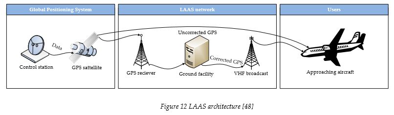
There are several GPS receivers located at an airport. The exact locations of these receivers is known and used in combination with the position determined by using the GPS signals to calculate the position error. This is used to determine a position fix which is then sent to VHF towers transmitting it directly to the incoming airplanes. By using this information it becomes possible to perform a precision approach during any weather circumstances. The LAAS correction signal can only be used by LAAS-enabled GPS receivers, which are primarily used in airplanes. The signal is also only usable within 20 to 30 miles from the airfield location with the LAAS installation [48].
RDS-dGPS (GRAS)
When the Low Frequency (LF) or Medium Frequency (MF) bands are used instead of the Very High Frequency (VHF) and Ultra High Frequency (UHF) bands, the name Ground-based regional augmentation system (GRAS) is used. The term “regional” indicates the larger geographical coverage. RDS-dGPS is a nice example of this type of application. The concept of RDS-dGPS is the same as with the LAAS architecture. The following figure should be read from left to right.
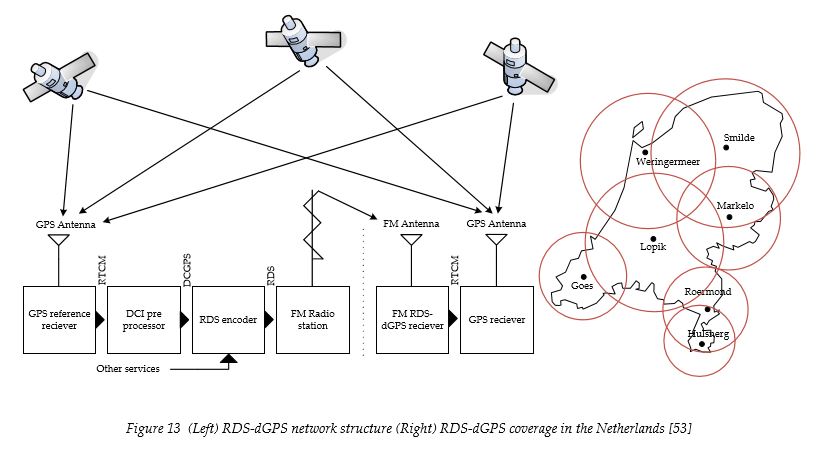
It starts with the GPS reference receiver. The correction data is determined by comparing the GPS calculated location to the exact and known location of the reference receiver. This data is then sent to the DCI pre-processor, which is located in Lopik and from there it is embedded into the Nozema FM broadcasts [34].
Real Time Kinematic GPS
Real Time Kinematic GPS (RTK GPS) is mostly used for land surveying or precision agriculture. It can provide centimetre level accuracy where other differential GPS technologies optimally provide sub meter accuracy. RTK GPS differs from DGPS in several aspects. In order to initialize RTK a minimum of five satellites is needed where DGPS only needs a minimum of three satellites. RTK also requires an expensive dual frequency receiver with the capability of realizing On-the-Fly initialization. In order to realize RTK GPS positioning you also need to install a base station and the position of this base station has to be known very precisely. The receivers used for the RTK GPS base station signals are quite large and therefore not suitable for ordinary positioning services [44].
High Sensitivity GPS
High Sensitivity GPS (HS-GPS) receivers are able to determine a position even when the receiver is used indoors. They do on the other hand show large measurement errors due to severe interference effects. There are some methods which can be used to improve the accuracy of HS-GPS indoors such as FDE (Fault Detection and Exclusion), but these types of methods also suffer from false exclusions and thereby a significant amount of incorrect positions [14].
Selective Availability
One of the features of the United States operated GPS is called selective availability (SA). Selective Availability can be defined as the intentional dithering of clocks on GPS satellites. This service represented a dominant error source for standalone GPS users but on the first of May in 2000 the United States announced that SA would be terminated, which was done the next day [28]. It should also be noted that on the 26th of June in 2004 an agreement was made between the United States and the European Union which ensured that the Galileo Positioning System signal wasn’t going to harm the navigation warfare capabilities of the United States and the North Atlantic Treaty Organization military forces. This agreement also brought forward that both the United States and the European Union would be able to address individual and mutual security concerns, and calls were made for non-discrimination and open markets in terms of trade in civil satellite navigation-related goods and services. Finally both parties also agreed on sharing technical information thereby eventually resulting in the establishment of a common civil signal [45].
Pseudo-satellites
Pseudo-satellites (pseudolites) are small transceivers which transmit a GPS type signal and are used to create a local ground-based GPS alternative (LAAS). The LAAS architecture described earlier required GPS signals where this LAAS architecture is especially useful for more precise positioning and positioning on locations where no GPS signals are received. There are a lot of possible applications for pseudolite technology, such as in future-generation Mars rovers [15]. The pseudolites are then deployed in a ground-based array and can provide centimetre-level and three dimensional positioning on Mars without the need for having a satellite constellation. Another possible application of pseudolites is the monitoring of bridge deformations [10]. Because of the satellite constellation geometry, the vertical component of 3D coordinates is less accurate in comparison with the horizontal components (see figure 10 & 11).
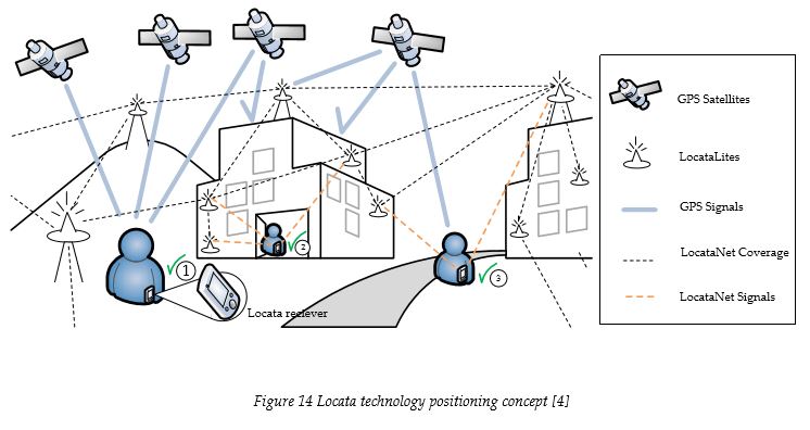
There has also been a lot of attention for the augmentation of GPS by using pseudolites. One of the solutions is called Locata, an invention of the Locata Corporation [4]. A network of time-synchronised LocataLites (pseudolites) is called a LocataNet. The idea behind the LocataNet is that no base station data is needed because LocataLite devices are time-synchronised. Time-synchronisation is of utmost importance because a nanosecond error in time can equate to an error of approximately thirty centimetres. The time-synchronisation is handled by communication between the LocataLites with the knowledge of the exact location of each LocataLite. The figure shown on the previous page (figure 15) shows how LocataNet is able to augment the existing GPS signals and thereby realize ubiquitous positioning (i.e. indoor and outdoor positioning). As figure 15 shows, positions can be determined by using only GPS signals (see 1 ), using a combination of Locata and GPS signals (see 2 ) and by using only Locata signals where no GPS signals are available (see 3 ).
There are several disadvantages concerning the use of pseudolites. Wang et all [26] published a list of concerns in the Journal of Global Positioning Systems. One of the main concerns is called the “nearfar” problem. The signal transmitted by the pseudolites can, if positioned too closely to the receiver, interfere with GPS and other signals, if the pseudolite is too far the signal won’t be noticed [26]. There are several solutions for this problem, but it is still in the exploration phase. Another problem is that of multipath (e.g. reflection of a signal by walls), especially when positioning services are implemented for indoor use.
GSM fingerprinting versus WiFi fingerprinting
The Global System for Mobile Communication (GSM) is currently the most widespread cellular telephony standard in the world, deployed in over 210 countries by more than 676 network operators. The GSM base stations are equipped with a number of directional antennas, which define sectors of coverage, called cells. A cell is allocated a number of physical channels based on expected traffic load and other requirements. Every GSM cell also has a Broadcast Control Channel (BCCH) which is used for example to transmit the identity of neighbouring cells to be monitored by mobile stations for handover purposes. This allows GSM mobiles to compare the signal strength of neighbouring cells and choose the best one for further communication. WiFi (Wireless Fidelity) is based the IEEE 802.11 standards issued by the IEEE LAN/MAN Standards Committee and is mostly used to connect PC’s, cell phones or PDA’s to the Internet, but it can also be used to create a local wireless data network. Traditionally the geographical area covered by one or more interconnected WiFi access points is called a hotspot.
Both these technologies can be used for positioning. GSM positioning is considered very promising because of four arguments. The GSM phones operate on a licensed band, which means that no interference is possible from microwave ovens and cordless phones. GSM also makes use of a managed network, which means that there is no interference from neighbouring access points tuned in to the same channel. Furthermore, the GSM network requires significant installation investments which results in a stable environment. Finally there is also the fact that the GSM networks provide a lot of network coverage [25], which in the Netherlands has reached the national level.
One of the most widely used GSM positioning technologies is that of cell positioning. Each mobile phone can be positioned to a cell, but the fact is that these cells vary in size. Even the smaller cells are considered too large to realize accurate positioning which is why we have chosen not to address this positioning technology. Two other approaches are fingerprinting and centroid, which can be used both for GSM as WiFi signals. Both these types of localization methods require a training phase where GSM-stamped traces are used to build a model of an environment, which is later used to determine the location of a device [25]. The following figures illustrate the accuracy of positioning with GSM and WiFi in indoor environments using the fingerprinting method.
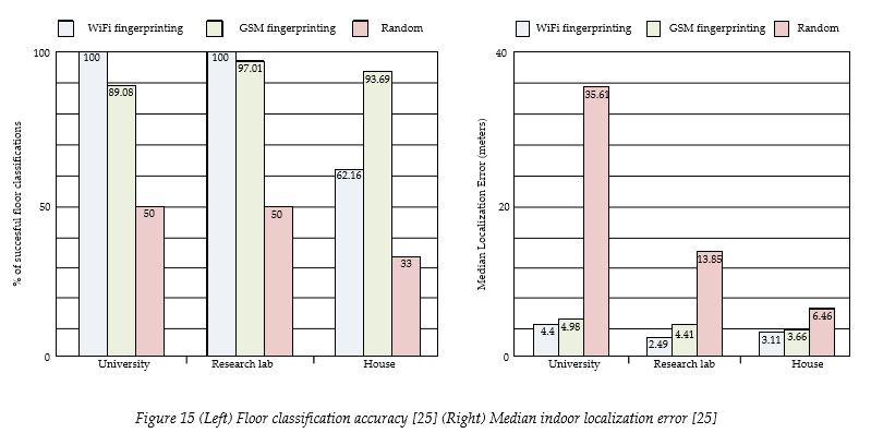
The random algorithm shown in the figures predicts a position by randomly picking one from the training set. This result is used as a lower bound on the performance of localization system. When we look at the left figure we see that WiFi fingerprinting provides a hundred percent success rate in the classification of different floors inside the University and the research lab. Localization within the house on the other hand is done better by using GSM fingerprinting, because of the absence of concrete walls/floors. Dutch buildings commonly have concrete walls and floors, which would make GSM positioning less suitable here as well, but when we look at the right figure we see that GSM fingerprinting is able to provide more accurate positions than WiFi fingerprinting in all the environments.
UMTS (Time of Arrival, Observed Time Difference of Arrival & Angle of Arrival)
UMTS networks can also be used to determine the position of a user. First there is the Cell Coverage Based Location Calculation. This method doesn’t require new functionalities in the mobile device and is based on the allocation of a dedicated channel or when the mobile is in cell_FACH or cell_PCH state. These states are characterized by the fact that no dedicated channel is allocated but enough information is exchanged to define the cell in which the mobile device is located at that moment. As with GSM cell positioning the accuracy heavily depends on the size of the cell which can be a few hundred meters in a dense urban area or 1 km in rural areas [13]. More accurate methods are based on the Time of Arrival or Observed Time Difference of Arrival (ToA, OTDoA) and the Angle of Arrival (AoA).
As the figure shown below illustrates, ToA and OTDoA enable self and remote positioning where AoA is only possible for remote positioning. We speak of remote positioning when the position of the receiver is known remotely by using its transmitted signals. The term OTDoA is used when the mobile has a clock error and an extra station is required, where ToA is only possible when everything is time synchronized. Concerning the positioning platform we are mostly interested in self positioning and thereby in using the ToA or OTDoA method. These methods are based on the mobile measurements of the relative arrival times of the pilot signals from different base stations. To do this, the signals of at least three base stations have to be received by the mobile device to determine the location. There are several factors which influence the accuracy of this positioning method. First the more base stations are received (with a minimum of three) the more accurate the position will be. Second the base station positions should be ideally in different directions of the mobile device. The third factor is the availability of line-of-sight, which also can provide more accurate positioning. The requirement for having at least three base stations is rather difficult to achieve with commercial cellular networks. The networks are deployed with the aim to avoid unnecessary overlap of cells, which maximizes the capacity.
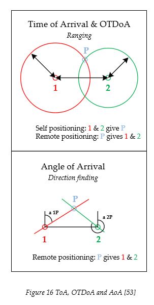
The figure shown below shows the probability of receiving the needed pilot signals from at least 3 base stations in realistic UMTS enabled areas [13]. The probability of having access to at least three pilot signals is 74 percent with the use of use of Idle Period Downlink (IPDL). IPDL facilitates the location measurements by using idle periods during which the mobile device is able to receive the pilot signal of neighbouring cells even if the best pilot signal on the same frequency is very strong. Without IPDL the probability is 31 percent [13].
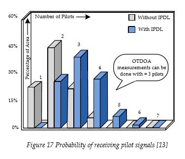
Ultra-Wideband
Ultra-Wideband (UWB) is a radio technology for short-range high-bandwidth communication. The regulation currently in place limits the use of UWB applications to indoor environment. Multispectral solutions, Inc. (MSSI) has built a prototype Ultra-Wideband PAL system (Ultra-Wideband Precision Asset Location) which was tested aboard a ship and at the University of Southern California (USC) [11]. This system consisted of a set of four passive UWB receivers, a UWB reference tag and a collection of active UWB tags. These active tags were designed to operate in burst mode transmitting short synchronization preamble followed by tag identification information once every 5 seconds. The following figure shows the reported positions in the ship with two layers of containers in between the active tags and the receivers. This figure shows that when the line-of-sight is blocked positioning sometimes is still possible because of UWB signals diffracting around edges and propagating through large cracks between containers.
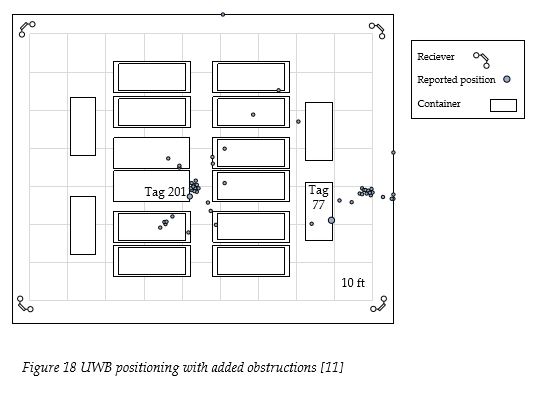
Bluetooth
Bluetooth is used to connect and exchange information between mobile phones, notebooks, PC’s and printers. It is a radio standard and communications protocol primarily designed for low power consumption and with a short range dependant on the power class. Currently there are three power classes, with a range from one to a hundred meters. There are two methods for realizing Bluetooth positioning, namely a direct method and an indirect method. The direct method requires a Bluetooth device which is programmed to handle the positioning task where the indirect method doesn’t require any programming. The client asks the Bluetooth device whether it is programmed for positioning or not, if so then the Bluetooth device is connected to the service to retrieve a position, if not then the indirect method is initialized, which means that the position is provided by a location server. Concerning security, it is possible to use authentication and security which makes it difficult to eavesdrop on information. Because of the frequency hopping (1600 times/sec) it is rather difficult to get the data from a Bluetooth connection. It is nonetheless possible and Bluetooth has therefore incorporated 3 security modes [20].
RFID
Radio-frequency identification (RFID) is basically a replacement for barcodes as we know them in stores and on books, but it can also be used for positioning. RFID consists of three parts, a transponder (RF tag) containing the information, the reader which gathers information from the transponder and a device to program the transponder. The transponder reacts on a specific wave sent by the reader by sending back data. The reader can have the ability to react on the data it receives from the responder or simply send it to a computer or server. The range of RFID transponders differs from between contact up to 20 meters. This is dependent on the power usage and the used frequency. The maximum allowed power differs per frequency and country because the frequency chosen for RFID is mostly based on the regulation of the country in which this technology is used [12].
Positioning technology discussion
The following figure shows the different technologies that can be used to determine a position, their respective accuracy and availability.

This figure shouldn’t be considered as a perfect blue print for determining which technology is most suited for the positioning platform as it is somewhat outdated and doesn’t incorporate certain positioning technologies. When we look for example at the right side of the figure, different technologies are shown which perform rather poorly on accuracy and above average on availability. Methods such as fingerprinting for the GSM signals haven’t been incorporated in this figure but should be taken into consideration when a positioning technology is chosen.
Three scenarios have been created for the following part of this section. Each scenario addresses a set of two variables, namely accuracy and availability. As a reference we have taken standalone GPS in the current form (i.e. without the Galileo Positioning System signals) which we have given the following characteristics: It has a high availability outdoors, no availability indoors and a limited level of accuracy.
One of the respondents (table 3, respondent 9) who has experience with both the tracking of vehicles and the tracking of people has brought forward that standalone GPS in its current form is suitable for tracking vehicles, but isn’t accurate enough to provide a satisfying tracking solution for handhelds carried by people outside of the vehicles. It is also not suitable for positioning people indoors, because of the unavailability of the GPS signals. By comparing other technologies with standalone GPS, a table is filled in and thus provides us a picture of the possibilities when choosing a specific positioning technology.
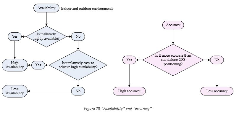
The figure shown above illustrates how availability and accuracy are determined in this context. The availability tree addresses both indoor and outdoor availability. When we for example take RFID as a positioning technology for outdoor environments, we start off by determining whether there is already outdoor RFID technology coverage throughout the Netherlands. This is not the case. The next question we have to answer is whether it is relatively easy to realize this, which also is not the case. We then come up with a low outdoor availability for RFID. When we look at the right figure we see that for example DGPS is more accurate than standalone GPS, which is why we can define DGPS as having high accuracy. The information we get by going through these decision trees can be used to look at three different scenarios, namely the positioning of people in outdoor environment, the positioning of vehicles in outdoor environments and the positioning of people in indoor environments. The next figure shows the different requirements these scenarios have concerning the chosen positioning technology.
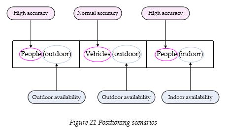
Positioning people requires an accurate positioning technology where positioning vehicles requires standalone GPS accuracy. When we take a look at the first technology in the following table, which is (HS)GPS, we can say that because of the High Sensitivity receiver, weaker GPS signals can be received. On the other hand the problem with the GPS signals remains, which are their poor penetrating ability and the strong possibility of attenuation. We can therefore say that (HS)GPS is limitedly able to provide indoor and outdoor positioning of people and that it is suitable for positioning vehicles. As another example let’s take a look at GSM. By using the finger printing method GSM signals can effectively be used to determine the position of a handheld indoors. The finger printing method on the other hand does require too much effort to realize positioning in outdoor environments. When we look at the table we therefore see that GSM is unsuitable for positioning people and vehicles outdoors (cell positioning can be used but it is not accurate enough) but it suitable for positioning people indoors. The rest of the table has been filled in accordingly. Red represents unsuitable, orange limitedly suitable and green suitable positioning technologies concerning the three scenarios. This table has been filled in by using the experiences of a technological consultant working for the space program of LogicaCMG (see table 3, respondent 8).
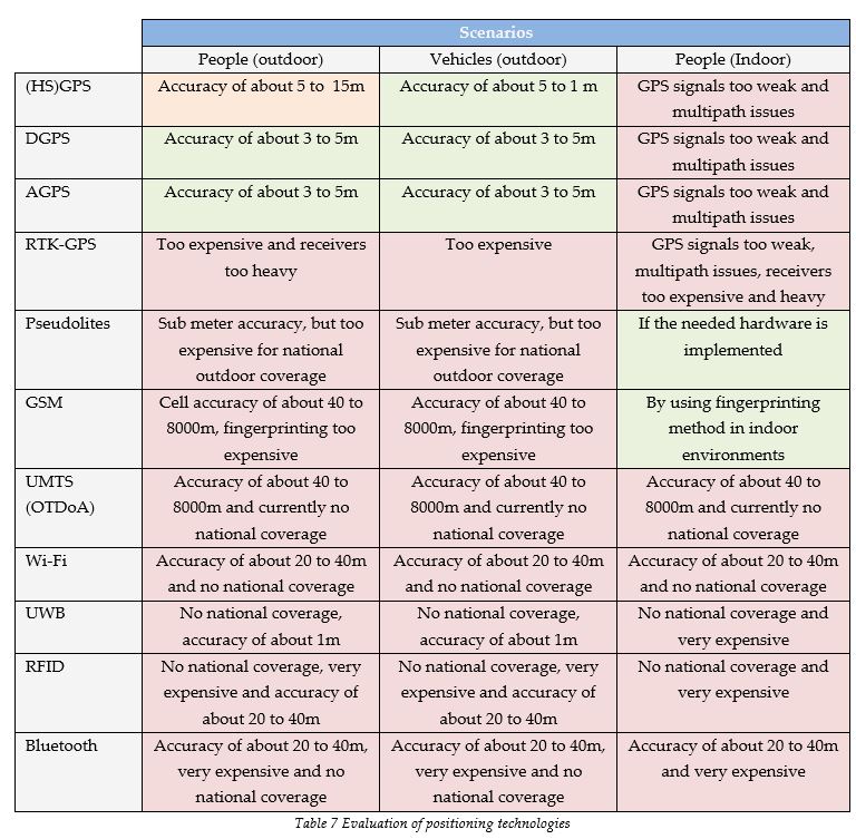
4.2 Data network
This section addresses the need for a data network. There are many different networks which can function as an underlying data network, but only a few are described here. The collection of networks presented here consist of popular commercial networks in the Netherlands, a network devoted to providing services to the security services or similar organisations and an anticipated network which is still in development.
C2000
The C2000 network and its ability to function as an underlying network through which the positioning data can be exchanged has been discussed earlier on in this thesis (see section 3.2). The conclusion was that it is possible, but only for a limited amount of vehicles or handhelds. The C2000 network handling positioning data from all the emergency service personnel at the same time is presumed unrealistic. The most ambitious solution brought forward by ISC was to use this network for the tracking of a limited amount of vehicles by implementing a network management server which is able to keep the voice communication working at all times. This solution is described in appendix III.
Mobitex
Mobitex, an OSI based open standard, is a public access wireless packet-switched narrowband data network which was developed in the beginning of the 1980’s. It became operational in 1986 and has since then developed an image of being reliable enough to facilitate critical services to first responders. The network is especially useful for short bursts of data with channels of 12.5 kHz wide. It makes use of Gaussian minimum shift keying (GMSK) with a slotted aloha protocol at 8000 bits/s with only around half of that available to end users to send or receive data [37]. Mobitex is considered as a 1G mobile communication network and thereby as a predecessor of the GSM network. The Dutch version is currently managed by RAM Mobile Data in the Netherlands [42]. The figures above indicate that this network isn’t suited for exchanging rich data such as video files, but the question remains whether the network is suited for tracking vehicles and maybe even handhelds. This question was addressed directly towards a policy manager of RAM Mobile Data who brought forward that the network was suitable to track both at the same time. This would require a lot of up scaling, but it was also clear that the exchange of positioning data towards people or vehicles on the street would require another network because of limited bandwidth on individual channels.
GPRS
General Packet Radio Service (GPRS) is often labelled as 2.5 G, which makes it a technology that can be fitted in between the second generation and the third generation of cellular networks (e.g. UMTS). GPRS is realized by using Time Division Multiple Access (TDMA) channels of the GSM network and has reached national coverage in the Netherlands. This is due to the fact that adaptations can be made to the existing GSM network to realize GPRS connections and no new infrastructure is really needed. GPRS is a packet-switched network, which means that more than one user can simultaneously use the same transmission channel [47]. In circuit switched networks, a connection uses the bandwidth of a circuit as long as there is a connection. The connection speed with GPRS depends on the amount of assigned TDMA (Time Division Multiple Access) slots. This amount is based on the GPRS Multislot Class of the GPRS receiver and the coding scheme used in the GPRS cells. The chosen coding scheme is based on a balance between possible GPRS connection speeds and the robustness of the signal (i.e. availability of the signal). A more robust signal results in larger cells but also a lower GPRS speed. More advanced networks are able to adapt the coding scheme according to the distance between the mobile and the base station. Within the GSM network speech is given priority over data, which affects the quality of data transmission continuously. In general a GPRS speed of 40 Kbits/sec should be possible. The Dutch public was also able to use EDGE (Enhanced Data rates for GSM Evolution) which is considered a 2.75 G network. EDGE was considered as an advancement of GPRS and was therefore also referred to as EGPRS (Enhanced GPRS), but due to the take-over of Telfort (i.e. the only EDGE provider in the Netherlands) by KPN, EDGE was shut off. Telfort’s EDGE service could theoretically reach a connection speed of 384 Kbit/sec [39].
UMTS & HSDPA
The UMTS licenses were auctioned in the year 2000 in the Netherlands for which a total of around 2.65 billion euro was paid [23]. These licenses were coupled with other requirements, such as providing UMTS coverage to municipalities with a population exceeding 25.000 people, at all the main highways, railroads and waterways, between the municipalities, on the highways running into neighbouring countries and on and around main airports. This coverage would have to be met 95 percent of the time at on a still to be defined service level. Some of the providers are having trouble meeting these requirements which had to be met by the year 2007. The costs for meeting these requirements are in some cases too high because of small market shares. Orange is a nice example of this, with only ten percent of market share one might consider to share coverage with other operators in order to meet these strict requirements, but network sharing isn’t allowed as a mean to meet these requirements, it is only allowed for increasing the quality of UMTS service which already meets these requirements. The Ministry of Economic Affairs have delayed planned controls to see whether the providers meet their requirements, because of the absence of an appropriate measuring method and till then ongoing procedures from the public to avoid the placement of UMTS towers [40]. The issue concerning the lack of national coverage of UMTS in the Netherlands is currently resolved by falling back on GPRS connections [30]. There are two main UMTS type services available at this moment in the Netherlands, regular UMTS connections which are limited at 384 Kbit/sec and thereby comparable to EDGE. There is also HSDPA (High Speed Downlink Packet Access), a third generation protocol which allows UMTS networks to reach a theoretical speed of 14 Mbit/sec. KPN, Vodafone, T-Mobile and Orange are currently all offering HSDPA services with a maximum downlink speed of 1800 Kbps (according to their websites on the 20th of August).
WiMAX
Worldwide Interoperability Microwave Access (WiMAX) is a wireless network based on the IEEE 802.16 standard. WiMAX enables communication at a distance of about 8 kilometres with a bit rate of up to 70 Mbit/sec for Line of Sight conditions and in case of Non-Line of Sight conditions a coverage of 50 kilometres can be realized [8]. The MAC layer design enables the support for higher layer protocols such as the Internet Protocol and Asynchronous Transfer Mode. Newer versions of the standard address handover procedures which are required for mobile use of the WiMAX communication network. UMTS technology has been designed as a mobile network and can therefore facilitate high speed mobility, but WiMAX on the other hand didn’t support mobility in the first versions of the WiMAX standard. In order to be able to facilitate high speed mobility or full mobility, the WiMAX standard issued FBSS (Fast Base Station Switching) and MDHO (Macro Diversity Handover). MDHO is somewhat similar to the soft handover in UMTS technology which is able to facilitate full mobility services [6].
Data transfer capabilities
As in the prior section a table is provided here which compares the different data networks for their suitability to function as a data network for the positioning platform. All networks are evaluated based on three scenarios. These are the tracking of vehicles, the tracking of people and vehicles and finally the tracking of both people and vehicles but also the facilitation of rich data exchange next to positioning data. Here C2000 has been taken as a reference. The following characteristics are linked with C2000: It has a low data rate and a low bandwidth.
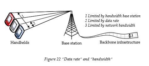
Figure 22 illustrates the distinction between data rate and bandwidth in the context of this thesis. The maximum data rate limits the speed with which data is exchanged between handhelds and the base stations. The base station bandwidth limits the total amount of data exchanged with a base station. If each handheld requires “N” data rate, this would mean that a base station with bandwidth “6N” can only facilitate the service for a total of 6 handhelds. The C2000 bandwidth is limited to 1 positioning message every second for every base station. With a frequency update of 1 positioning message per second this would mean that only 1 handheld is able to use a base station continuously. The networks described in this section all have the ability to facilitate data exchange at a high mobility. The choice not to look at the positioning of only people or handhelds can best be described by looking at the following figure.
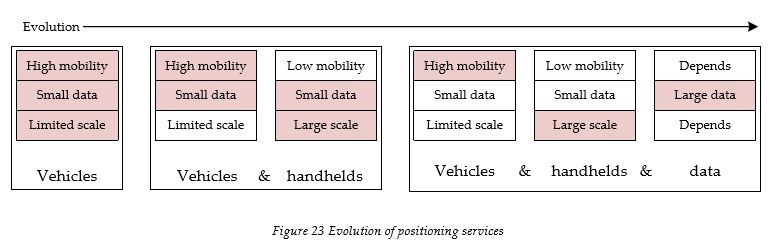
The horizontal axis represents the evolution of the positioning platform as we conceive it. The red coloured factors are determinant factors. When we look at the current situation the most widely used positioning variable is that of vehicles. One of the reasons is that standalone GPS doesn’t provide real accurate positioning. Another reason is found in the scale because there are far more people than vehicles. The next step will be that of adding handhelds followed by data exchange. Data from the perspective of this research is considered as the step after positioning. Data exchange requires a lot of bandwidth and high data rates towards and from the handhelds or vehicles where positioning only requires the exchange of a position which can be put in a small data package. The following figure takes mobility as a given and looks at both the data rates and the bandwidth.
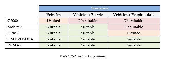
When we look at this figure we see that Mobitex is considered suitable for tracking vehicles, where C2000 isn’t. Mobitex has a very low data rate, which is also the case for C2000, but Mobitex brought forward that is was relatively easy to scale up the network. This scaling is done by placing more base stations and thereby increasing the bandwidth. Both these technologies on the other hand aren’t suitable for the exchange of other data. GPRS, UMTS/HSDPA and WiMAX are suitable for all the scenarios, because of the high data rates and the large bandwidths.
4.3 Reliability
The term reliability can be addressed in various ways. A technology or network here is considered reliable when it remains operational during high usage. This can be during a disaster or at large events such as New Years Eve or the Queens-day celebrations in Amsterdam. The next section addresses the flexibility of the positioning technologies and data networks. It can be said that a flexible technology or data network is able to provide the needed reliability, but a technology or network can by itself already be reliable because of the way the infrastructure is designed. Take for example GPS, a highly reliable service which isn’t influenced by the amount of users, but on the other hand a rather inflexible service because no adaptations are done on the signals when this is needed by the users. The following tables address the reliability of the positioning technologies and the data networks. Red is considered unreliable, orange represents limited reliability and green is used for reliable technologies and networks.
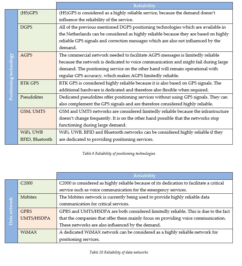
4.4 Flexibility
Flexibility in the context of this thesis is the willingness of the owners (e.g. shareholders) to change their network according to specific needs from the market (i.e. here this would be the needs of the emergency services). This also concerns adding functionalities which don’t necessarily alter the existing infrastructure. A public owned network is considered as the most flexible form. The following tables provide descriptions of both the positioning technologies and the data networks concerning the level of flexibility. The colour red is used for inflexible, orange for limited flexibility and green for flexible technologies and networks.
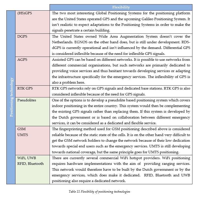
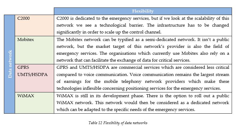
4.5 Security
We consider a positioning technology to be secure if only authorized people are able to use the positioning technologies and thereby determine their own position. The same term when applied to data networks addresses the availability of positioning information. A data network which is considered secure is a data network from which no usable information can be retrieved by unauthorized people.
There are two types of positioning services, namely self positioning and positioning done by the positioning technology itself. Self positioning indicates that the positioning technology provides the information needed to determine a position at a mobile location. This is considered less secure because unauthorized people might be also able to use this technology. In order to realize remote positioning one has to get this positioning data back from the network transmitting the signals. This type of positioning is considered more secure, but is more difficult to realize with commercial networks because of the need for their involvement in calculating a position. Concerning data networks there is the options to use authentication and encryption, which are the most obvious ways to ensure that only authorized people gain access to sensitive information such as positioning information. When both are used, first a user has to be authenticated. After successfully identifying the handheld and thereby indirectly the person holding the device, a decryption process is initiated during which an encrypted message is taken apart and put back together by using a key only available to authenticated handhelds. The following table addresses the security levels of the positioning technologies and data networks. Red indicates a low secure, orange a medium secure and green a highly secure positioning technology or data network.
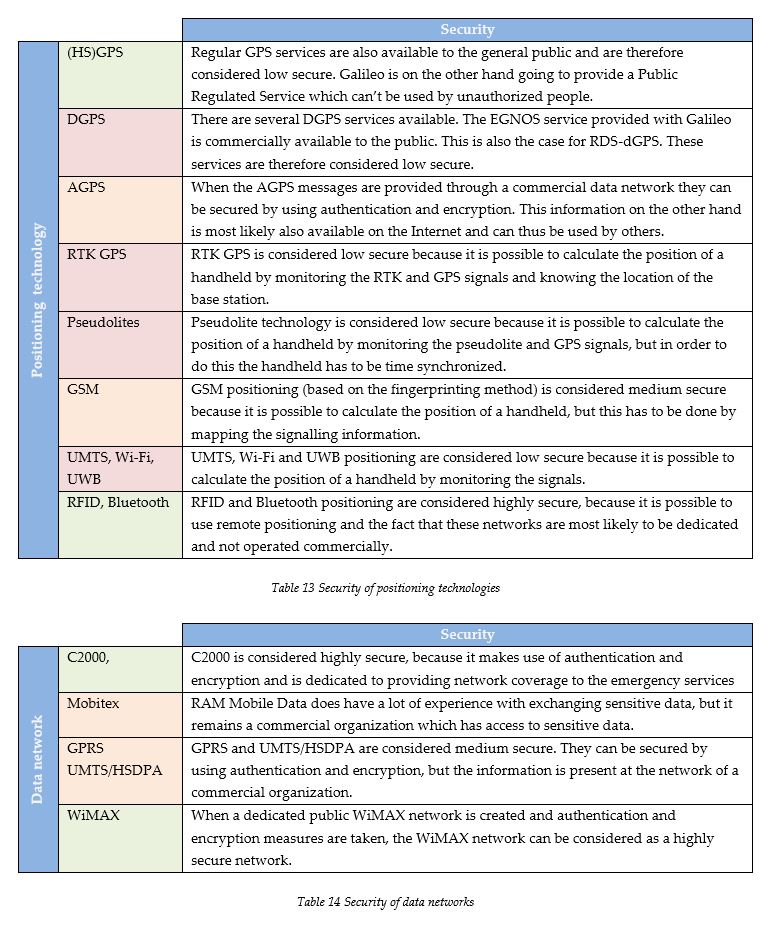
4.6 Connections with other systems
As the conditions and requirements have shown us (see appendix VII), there are some systems which have to be connected to the positioning platform. The connections that need to be made with existing systems or systems which are currently being developed are based on wired data communication. Wired communication or fixed line data networks can be expected to be more reliable than wireless networks, due to less complex communication protocols. The choice that has to be made here is between visualizing this data remotely and the actual exchange of the information. The main difference between these two options lies in the fact that the information sent in the first scenario theoretically can’t be sent to other parties, where the second scenario does provide this option.
When the information is only visualized at the workplaces of the parties which have to be connected, application servers can be used. This would mean that the database layer isn’t exposed. It is also possible to run applications at the location of the connected party, but this would mean that the positioning information also has to be present at that location. By using encryption measures it is possible to limit the usability of the information to the dedicated applications run by the connected party, but there is always the possibility to decrypt these messages. The last option is to just send the positioning information in a standardized manner and allow the connected parties to use this information by incorporating the information in their own applications, which off course poses severe security and privacy risks concerning the information that is exchanged. A nice example of using application servers can be found for example within LogicaCMG. They make use of Citrix application servers which allow employees to connect and use applications remotely. This is called a Remote Access Portal (RAP) and makes use of java software run on the client side. Application servers are also used to provide Web-Based applications.
4.7 Research question III
This chapter addressed the technological options for the positioning platform and thereby addressed the following research question:
III. What are the technological options for this positioning platform?
This chapter was limited to providing descriptions and assessments of options which are already or are going to be available in the Netherlands in the future. This chapter has also brought forward that there is no such thing as an ideal positioning technology or data network. Each technology has its limitations and each limitation poses a threat to meeting the diverse set of conditions and requirements brought forward by the different stakeholders.
5 Organizational arrangement options
This chapter addresses the organizational variables of the positioning platform. The amount of organisational options is infinite, which is why a conceptual basis is given that can be used to map these options. The chapter starts by describing the conceptual basis and then goes on to the actual mapping of the different options. The last section of this chapter briefly recaps the findings and answers the corresponding research question.
5.1 Conceptual basis
The added value of the following model lies in the fact that it provides a way of conceptualizing complex variables and thereby means of comparing different configurations. First a description of the model is given. After this description the current status of positioning within the field of emergency services is modelled. This conceptual model in adapted form can be applied to other platforms but is most applicable to this research in the form shown below.
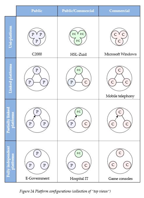
Figure 25 shown on the previous page has two dimensions, namely that of commercialization on the horizontal and that of connectivity on the vertical axis. The circles represent different national positioning platforms and the highest number of platforms in the model shown above is three with the merged circles representing only one platform. The inner circles are, in this case national emergency services, but we can apply the model also for example on mobile telephony in the Netherlands. The inner circles then represent individual commercial mobile telephony providers such as Orange, Vodafone or KPN for example. As the figure shows, the circles in this case aren’t attached to each other, but they are linked. The different organizations use the same technology and provide access to each other’s networks. This can be the principle of roaming but also regular call terminations. This link would have to work both ways, which is illustrated by not using arrowed lines. The most relevant example for us is that of C2000 situated at the top left corner of the figure. The C2000 network is a public uni-platform because the different emergency services use the same platform and the network is publicly owned.
5.2 Information exchange
Let’s take another look at the connections between different platforms. The exchange of information is visualized by using (dashed) lines and arrows. The following figure takes a closer look at a fictional platform configuration.
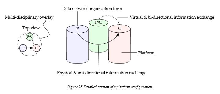
All the emergency services brought forward that a connection between the different platforms should be made with the emergency control centre at all times, which is why the choice has been made to use it as a permanent asset in the platform model shown in figure 25. The arrowed lines in figure 26 illustrate the direction in which information is exchanged between different platforms. The arrowless line illustrates information exchange between the emergency services in both ways. Whether a line is dashed or not is determined by the way the information is provided. Section 4.6 described that there are two ways to exchange information. The visualization option is illustrated here as a dashed line, where a normal line represents the physical exchange of positioning information. The top view shown on the left of the figure shows these connections, but also the connection of these platforms to a multidisciplinary overlay which represents the integrated emergency control centres.
5.3 Commercialization
The variable of commercialization is used in the columns of the model given in figure 25. Three different types of commercialization of platforms are distinguished, namely public, a combination of public and commercial and fully commercial platforms. The definition of “commercialization” in this model concerns the ownership of the data network which is used to exchange the positioning information.
The choice to use commercial networks or start a public/private partnership can be made on several levels. Within some organizations this choice is made at the regional level, where other organizations have made the decision to leave this choice up to individual institutions. The use of layering is necessary to be able use the model for more complex configurations and is described in section 5.5. The choice can also be made to have a public network managed by a commercial organization, or the other way around. The management of the platforms is discussed in the following section.
5.4 Management
The difference between management of a platform with the variable “commercialization” lies in the fact that with “commercialization” we meant property, where management in the context of this thesis is directed towards keeping the network running and providing the necessary services. It is for example possible to have a commercial organization manage a public platform. The different commercialization forms for management are shown in the left part of the following figure. The stakeholders have their own conditions and requirements and sometimes conflict occur. Some conflicts can be handled by means of negotiation, in other cases the majority rule might be used or a governmental decision is issued upon all the emergency services. The aim of this research is also to come up with a management design which is most suitable for the positioning platform and to which the stakeholders are willing to commit.
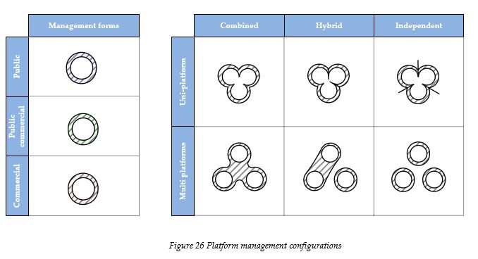
The figure on the previous page also illustrates different types of management configurations. These types are: combined, hybrid and independent management. The combined form of management is a scenario in which one organisation manages a uni- or multi-platform. This would be the case for instance if only one platform was realized, which was used by every emergency service and where ISC took on the role of managing the platform. The configuration shown on the top right corner of the figure is the representation of one platform, used by all the emergency services, but with management of this platform being done by three different organizations. This would be the case for instance if C2000 was used as a communication network and every emergency service was allowed to change the network. The configuration shown on the lower right of the figure illustrates independent platforms with all their own management, where the configuration on the lower left of the right figure represents independent platforms with a shared management organization. The configurations in the middle column are hybrid forms. As with commercialization the choice for using a specific type of management configuration or form is made at different levels. This is realized in the model by using a layered approach, which is shown in the following section.
5.5 Number of platforms
The following figure illustrates that several layers can exist which represent different geographical scales. In every configuration the local layer is shown, which consists of the operational units and institutional organizations. We consider them as the providers of the positioning information, even though they don’t necessarily generate and send this data when remote positioning is used. The other two layers are the national and the regional layer.

This figure shows that organization A has a national public owned and managed platform which gathers the positioning data from the operational units, but not all the local organizations use this service. Organization B retrieves the positioning data and also provides this information virtually to the regional level. Here some regional organizations don’t participate. The data network here is chosen at the local level. Organization C doesn’t have a national platform. Here all the regional organizations receive the positioning data and send this to the IECC. They also provide this information back to the local level. This is done because the positioning information was sent directly by the operational units to the regional organizations. This distinction between operational units and institutional organizations also shows that organization A and B don’t have any positioning information at the institutional level. Organization C also gets the positioning information of organization B, but this is only done virtually. As the top view brings forward, all the organizations provide positioning information to the IECC. The top view basically represents the flattened image of these layers and their links, with the IECC added on top. Figure 25 should also be considered as a collection of top views representing different platform configurations.
In order to provide the configuration of the current status of positioning services within the field of public safety, we have to provide a structured list of how each variable is reflected in the field. The following list is based on the information provided by first phase of the research (see chapter 2 and 3).
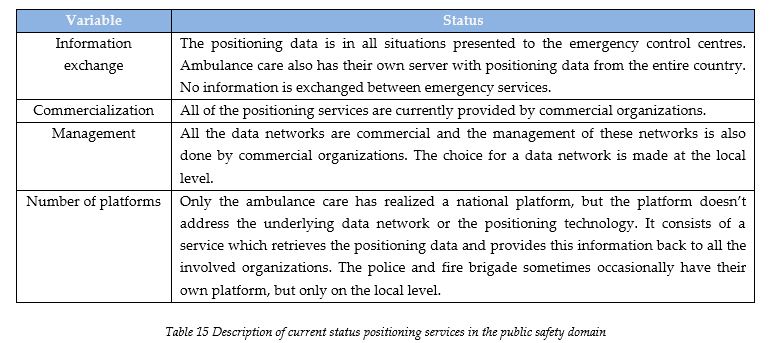
This following configuration addresses all the variables mentioned above and thereby shows a layered configuration of the current status of positioning services in the public safety domain.

This figure illustrates the different levels of integration. The ambulance care shows integration at the national level. The national ambulance care positioning platform (i.e. Ambunet) on the other hand doesn’t cover the data network, which is why the management of these networks is shown at the local level. The reason why the national ambulance care platform has been depicted as a commercial platform can be found in the fact that all the local ambulance care organizations make use of commercial networks to send the positioning data. The connections shown between the fire brigade and the police with the ambulance care are in fact police and fire brigades using the ambulance care’s positioning platform. In case the police and fire brigades use their own platform, the management of these networks is then also realized commercially and chosen at the local level. All the disciplines that use positioning services do provide positioning data to the emergency control centres, but no positioning information is shared between the disciplines. The figure also shows that not all the fire brigades and police organizations make use of positioning services.
5.6 Implementation
The positioning platform has to be used after implementation by all the emergency services. A platform which isn’t used or in some cases is attracting too much resistance should be seen as a flaw in the design disregarding its attractiveness from a technological or mere design perspective. In other words, user acceptance is very important in this case because the design incorporates elements which affect both the front and the back office of the different involved organizations. When we look back at the conditions and requirements the different organizations provided concerning the implementation of the positioning platform we see that timing is an important issue. Some technologies are needed in the near future, where other technologies are already used and therefore should be provided by the positioning platform immediately. There are also differences between the urgency brought forward by the different organizations. This poses a threat because the costs of certain technologies might have to be paid for by organizations that don’t need them at all. This is for instance the case for indoor positioning from the perspective of the ambulance care.
The need for a positioning in general is also something that is being debated. Ambulance care for example already have a positioning platform and don’t really see why they have to be involved in a multidisciplinary positioning platform. When we look back at the conditions & requirements (see appendix VII), we see that each organization considers itself as being different from others. This is something that can also be identified within one discipline. The interview with the policy officer of the emergency control centre (table 3, respondent 2) for example brought forward the differences between the regions based on differences in geography and population density. A balance has to be made when it comes to such conditions between the desired level of flexibility and the manageability of the implementation of the platform as whole. When decision making power is given to each organisation, at the lowest desired level, the management of the project will become too complex and difficult. When too little decision making power is delegated, this might affect the attitude towards using the services. The fire brigade provided a nice example of this by claiming that a service shouldn’t be forced upon an organization when it isn’t needed. On the other hand, if the service is only going to be useful in very specific circumstances it won’t be used unless people are familiar with it and perceive it as useful.
Another aspect concerning the implementation of the platform is the possible development of the data network, the positioning technology, the handhelds and other infrastructural elements. When commercial organizations become eligible to provide a service to the government, which can be the development the platform, the management of the platform’s underlying network or even the manufacturing of the handhelds needed to make use of the positioning services, an open invitation to tender is issued. This tender follows a strict order of processes, which are shown in appendix VIII. The main selection criteria here are the experience of the commercial organization in providing similar services and their fiscal capacity [16].
5.7 Consensus
In order to create consensus on the need for a positioning platform, different incentives should be used. The interviews brought forward two very important factors which are disaster relief and the upcoming safety regions. On the first sight the link between these two factors seems obvious, but even if we consider the safety regions as a direct effect of the Dutch government’s policy towards realizing effective disaster relief, we do need to keep in mind that the move towards implementing safety regions has already been initiated. This thereby becomes a factor on its own which can provide strategic options for the creation of consensus for the positioning platform. This perspective is illustrated by the following figure, which also brings to the attention the possibility to find other strategic options related to disaster relief or the emergency services in general.

5.8 Research question IV
This chapter brought forward the organizational options of the positioning platform and thereby addressed the following research question:
IV. What are the organizational options for this positioning platform?
As mentioned at the beginning of this chapter, the list of organizational options is endless. The choice was made early on to consider every non-technological element as an organizational element. There were nonetheless some variables which could be analysed by using a conceptual model. This model provided the means to compare different organizational configurations and make some abstract notions more concrete. This chapter also brought forward that an organizational architecture or design is confronted with a big problem. Ideally one would like to have a highly standardized organizational architecture, meeting all the conditions and enabling multidisciplinary operations during disasters. The problem lies in the fact that this ideal picture is rather unrealistic and is most probably confronted with resistance from the different involved organizations. On the other hand, the main motivation to realize an integrated vision of the positioning platform is undermined if we try to meet all the conditions and requirements. This forces us to design an organizational architecture which takes into account this problem and satisfies all the involved organizations sufficiently by addressing their most important conditions and requirements.
6 Technological architecture design
This chapter will provide the technological architecture of the positioning platform based on the conditions brought forward by the different stakeholders and the technological options described and analyzed in the fourth chapter. The design choices made at the technological level also affect organizational decisions which are motivated in the following chapter. The technological architecture addresses the two main elements which were presented earlier in this thesis, namely the positioning technology and the underlying data network. Chapter 4 explored the possible technologies and networks which could be used for realizing the positioning platform. This chapter converges the options towards a solution by incorporating the provided conditions and requirements. The other technological variables are addressed in relation to the positioning technology and the data network and are therefore not addressed separately as in chapter 4. An integrated approach is used here in order to realize a multidisciplinary positioning platform for the entire public safety domain. The design method is based on a pragmatic approach because the choices that had to be made influenced each other and thereby resulted in more complexity.
6.1 Choosing a suitable positioning technology
In order to come up with a suitable design we have to take a look at the different tables that were provided in the fourth chapter. These tables compared the technologies and networks on different scenarios and variables. The following table provides a full comparison of the positioning technologies. There are two scenarios which will be addressed separately during the design, namely outdoor and indoor positioning.
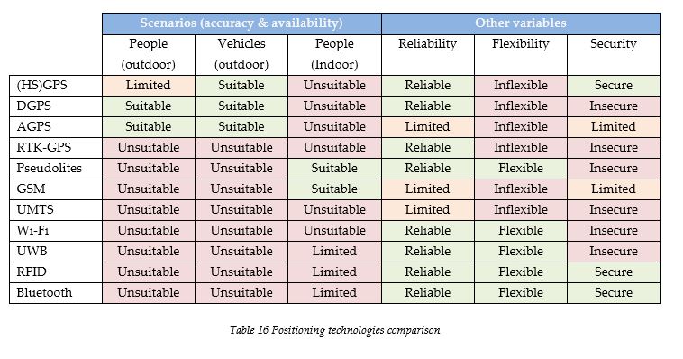
Outdoor positioning
The first two scenarios clearly indicate the usefulness of GPS based technologies for determining positions outdoor, but we do have to incorporate the fact that these technologies aren’t really flexible. This problem on the other hand is a problem which we mostly have to face when we try to realize indoor positioning. The availability of these signals is very high in outdoor environments and this has to do with the fact that satellite based positioning technologies are designed for providing outdoor positioning services. When we take these facts into consideration, a choice has to be made on GPS based technologies for outdoor positioning of people and vehicles. Standalone GPS on the other hand is only suitable to position vehicles because of the inaccuracy of the position. This limits us thus to the following technologies, Differential GPS and Assisted GPS.
The development of a positioning platform in the Netherlands does have a connection with Galileo, in which the Netherlands is a partner. The fact is that Galileo signals aren’t yet available and it might take a while before this is the case. The ideal situation would be to implement the positioning platform at a moment when the Galileo Positioning System is operational. This would enhance the reliability and increase the accuracy of the platform by using receivers for several positioning systems. The platform on the other hand should be operational by then, which forces us to consider the existing GPS as the technological standard. This principle can also be used concerning the EGNOS wide area augmentation system. EGNOS can be used to realize more accurate positioning, as required for the positioning of people, but the EGNOS augmentation system will most likely be operational at the same time Galileo does. This has to do with the fact that EGNOS is designed to provide accurate positioning for the SoL service Galileo is meant to provide. The problem we face because of this is that we have to determine which technology is best suited to realize accurate positioning before Galileo and EGNOS are operational. To do this we have to make a choice between DGPS and AGPS in general. Assisted GPS will require an underlying data network which is able to provide the needed bandwidth for sending information concerning the GPS signals, but DGPS can also be based on other terrestrial networks. At this moment there is no public owned network available to the emergency service to realize AGPS. The C2000 network isn’t able to facilitate this need, so therefore another network has to be considered or we have to look at DGPS options. This choice is to a large extent dependant on the choice concerning the data network which is given in the following sub-section of this chapter. The choice is made and motivated in section 6.3. The table does show that AGPS is considered less reliable, but this is based solely on the assumption that a commercial data network is chosen (see table 9). A public network would on the other hand make it more reliable.
Indoor positioning
When we look at indoor positioning, the flexibility of the positioning technology becomes important. The table shows that only GSM and pseudolite positioning are suitable for indoor positioning and by incorporating the needed flexibility this brings the selection down to only pseudolites. Pseudolite technology is considered as complementary to the GPS signals, because it simulates the same type of signals. It is therefore also possible to combine pseudolites with a GPS based solution for outdoor positioning. The problem here is that the availability of pseudolite technology is rather limited because of the current state of the technology and we do have to take into consideration that practically all the emergency services brought forward that the platform should be implemented as soon as possible. When we look back at the conditions and requirements the stakeholders have given (see table 24 in appendix VII) we see that the fire brigade is currently the only organisation really interested in having indoor positioning services. Pseudolites seem very promising and would be the most obvious choice. This choice would then also provide a strategic option to link the technology with the GPS based technology chosen for outdoor positioning, thereby creating an all-round positioning system, or ubiquitous positioning platform which can be used by all the emergency services. The choice here is therefore to hold of implementations for indoor positioning because of the promising pseudolite technology. The inflexibility of the GSM positioning technology isn’t considered an option because of the need to change the infrastructure in order to realize positioning in specific buildings.
Securing the positioning technologies
Concerning the security of the positioning systems, we have to ask ourselves whether it is a problem if unauthorized people are able to determine their own position by using the chosen positioning technology. We have to take into account the fact that the general public is already able to use GPS positioning. There is on the other hand the risk of terrorists gaining access to a more accurate positioning system which they then can use for missile guidance systems. The DGPS based technologies are all available to the public and there is a chance that the pseudolite technology can be used for more accurate positioning by unauthorized people as well. The first issue is something that has to be addressed by the organizations providing such services. The issue concerning the pseudolite technology can be addressed by limiting the by then commercially available pseudolite receivers to only calculate a position when the receiver is moving up to a predefined maximum speed. Vehicles would then not be able to use the pseudolite signals, which, as we mentioned earlier (see figure 22), isn’t required because they only require general GPS accuracy.
6.2 Choosing a suitable data network
The next choice that has to be made is the one concerning the data network. As with the previous subsection, we first provide a table made up by putting together the tables that were given in the fifth chapter of this thesis.
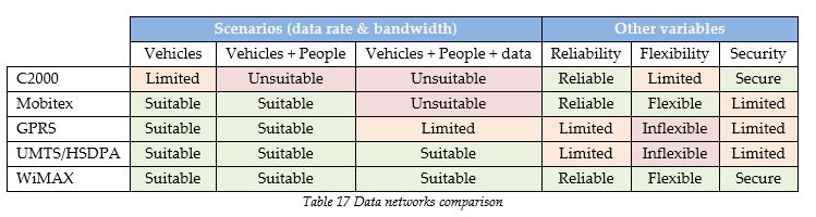
The first thing we can do here is eliminate the C2000 network as an option for functioning as a data network for the positioning services. This is due to its limited ability to facilitate the exchange of positioning data. The other networks all look suitable, with the exception of Mobitex and GPRS, but we shouldn’t leave them out as options this easily. When we take into account the other variables, namely reliability, flexibility and security, we encounter the inflexibility of GPRS and UMTS/HSDPA. The problem with commercial providers of communication networks is the fact that they are unsuitable for upgrading the network for the sole purpose of facilitating a positioning service for the emergency services. Their main income is still realized by providing voice communication and this can be expected to remain. Even if we neglect this factor, the limited reliability of the networks becomes an issue. The network has to be operational at any moment which requires a lot of redundancy in the network. This redundancy can’t be expected as it most likely won’t be cost effective for the commercial providers. This leaves us with Mobitex and WiMAX as possible solutions to our problem. The most promising looking data network seems to be WiMAX, but the same problem as with the prior mentioned pseudolites is faced here. WiMAX networks are still under development and it is unclear when they can be rolled out for the realization of the positioning platform. After WiMAX the Mobitex network looks most interesting.
Mobitex confronts us with two problems. First there is the fact that it can only support short bursts of data. It can be scaled up to support the exchange of positioning data, but the limitation towards the data rate remains and it is therefore not really future proof as one has to expect the need for data exchange towards and from mobile devices to increase. Next to this there is also the problem that the positioning information is available to the commercial organizations providing the Mobitex services. A positive element of this network on the other hand is the fact that it can be considered most reliable next to a possible WiMAX dedicated network implemented by the government. If integration between different platforms is needed or one platform for all the emergency services is considered the most ideal scenario, a time frame up to the realization of a WiMAX network has to be bridged. The choice has therefore been made to come up with two different platform implementation phases. The first phase dictated by the choice for a Mobitex network and the second by the implementation of a WiMAX dedicated network. We use the term “dictation” because these choices affect other decisions that have to be made in the design. As discussed in the previous section the choice between DGPS and AGPS still has to be made.
During the second phase the WiMAX network can be used for more accurate positioning (AGPS), but with the expectation of Galileo and the accompanying EGNOS augmentation system (DGPS) being operational by then this becomes more of a luxury issue. Mobitex is considered unsuitable for AGPS, because of the costs for exchanging this data continuously and the limited available bandwidth. Using GPRS or UMTS/HSDPA for augmentation purposes is also considered too costly. The choice has therefore been made to use a terrestrial based augmentation system, namely RDS-dGPS. There are no additional costs and the correction messages are broadcasted continuously.
Securing the Mobitex data network
We haven’t yet made a choice between a commercially managed and public owned WiMAX network or a public managed and public owned WiMAX network. This choice is made in the following chapter (see section 7.3). We are on the other hand confronted with a commercially operated and owned Mobitex network and the fact that sensitive data is available to this organization. This remains a sensitive issue even when we use authentication and encryption. This information is on the other hand currently also going through commercial networks. When the positioning platform is implemented nationally, covering multiple emergency services, this can pose a political threat which we rather tackle right away. This issue can best be resolved by using a public organization auditing the security of the positioning information. This organization can be the ICT Control Centre. This choice is made because it is assumed that in case of such a platform, technological security measures won’t suffice from a political perspective.
The immediate need for mobile data exchange
It is important to facilitate the needs of the emergency services and where this isn’t possible, the option has to remain for the involved organizations to look for solutions elsewhere. This is currently also the case when we look at the emergency services and their choice to use commercial GPRS and UMTS/HSDPA networks. The Mobitex network won’t be able to facilitate large amounts of data exchange towards handhelds. With this in mind, the option to use GPRS or UMTS/HSDPA networks should remain during the first phase because of the existing need to exchange data. Concerning the exchange of positioning information towards mobile devices during disasters, the same option has to be available.
The choice is made not to allow the exchange of positioning information during regular operations, but only during disasters and for testing purposes. This can also only be done when initiated by the Emergency Control Centres. The connections with the GPRS and UMTS/HSDPA networks should also be secured by using authentication and encryption. It is not recommended to have a public organization present at the GPRS and UMTS/HSDPA network providers, because of the rarity of disasters and the political pressure on having effective disaster relief. We consider technological measures to be sufficient in this case, but do advise putting strict arrangements in place in case these commercial networks have to be used during disasters and tests. Mobile data exchange is facilitated by the WiMAX network during the second phase. This concerns monodisciplinary positioning information during regular operations and multidisciplinary positioning information during disasters and tests. During this phase limitations should be put in place concerning the use of other networks in general. The steps that have to be taken to ensure that this transition takes place are described in the following chapter (see section 7.5 and figure 33).
Connection with other systems
We also have to take into account the connections that have to be made with other systems. As described in chapter five, there are two options concerning the exchange of positioning information, namely the visualization of information or the actual exchange. This problem is also faced to some extent during the first phase, because of the presence of the information at a commercial organization (i.e. the Mobitex network). It is on the other hand considered to be too expensive to have a public organization audit the security at each connected organization. This would for example be practically impossible if general practitioners offices are connected the platform. This forces us to consider the visualization option, which was also brought forward by the emergency control centre (see section 3.2, IECC). The advantage here is that it takes away a lot of the security issues, especially when we take into account the expected political pressure. Even though we expect technological measures to be insufficient to satisfy the government, we also realize that the other option is not to exchange this information at all. Because of the added value the sharing of positioning information can provide, but also because of the needs for this expressed by the stakeholders, we have chosen to use the visualization option. In this case application servers are run centrally and thereby prevent the connected organizations from unintentionally sharing this sensitive data with other parties. The choice to have a public auditing organization present at the Mobitex exchange network remains, because of this company playing a key role in collecting and exchanging the positioning information during the first phase.
The positioning information
The positioning information sent by the handhelds is linked with a unique identification number. This unique number is sent as Metadata and refers to a specific person working in the public safety domain. More information can be linked with this identification number and stored on a central database server. This could be information concerning the name and function of the person holding the device. The handheld identification number is also used to indicate specific authorization levels. Whether or not to use a specific authorization level is dependent on the function of the person carrying the handhelds. During the first phase specific emergency service personnel should be able to receive multidisciplinary information during disasters and tests. The Emergency Control Centre can verify whether an emergency satisfies these criteria and can then choose to provide some of the handhelds this information. An archiving database is also used to store the positioning information. It might be interesting to look back at the positioning of people and vehicles in the past (e.g. to evaluate disaster relief), which isn’t possible with the regular database server holding dynamic positioning information. Theoretically there is only one positioning platform server in the Netherlands but redundancy can be used by placing backup database servers.
Regional servers and applications
Both positioning platform phases make use of regional emergency service positioning servers. This can be a location with only the server as long as all the emergency services of the corresponding discipline within the region are able to connect to it. Each emergency service discipline inside a region has a dedicated positioning server which receives the positioning information relevant to that region and the specific emergency service from the central database. These regional servers aren’t connected to each other and thereby prevent the emergency services from sharing positioning information with each other at this specific level. The regional servers are also connected to an application server. This server is used to provide each local emergency service (e.g. a municipal fire brigade) a virtual version of the positioning information. Theoretically there are no application servers at the location of the national server, but this can be implemented when needed to perform a back up function during disasters. Application servers are also placed at the emergency control centres. The positioning information only leaves these locations virtually. The emergency control centres are given access to multidisciplinary positioning information concerning their own and maybe their neighbouring regions. They are able to use their existing software to make use of this information because it is physically sent to them by the national positioning server. The application server used at the regional emergency service prevents individual emergency services from sharing sensitive data with third parties. Connections with non-emergency services are only possible at the regional level and applications are also standardized at this level.
Levels of standardization
The police aren’t fire fighters and the ambulance care can’t be seen as police officers with medical knowledge. The differences between emergency services have been brought forward continuously during the interviews. Each emergency service has its own conditions and requirements and these differences can even be seen within a region or between individual institutions. When a national positioning platform is realized a risk which has to be acknowledged is providing services without acknowledging these differences. The other side of the coin is the fact that highly personalized services are very expensive and bring along a lot of other limitations.
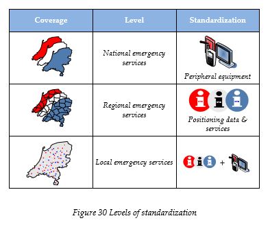
Figure 30 shows that three different levels can be distinguished which correspond to different levels of standardization. At the national level the choice has been made to look at the differences between emergency services in general. The fire brigade, ambulance care and the police are expected to require different services and peripheral equipment. Providing a generic service will not address the specific needs the emergency services have. Positioning data will be used differently by different organizations and the aim of the positioning platform will be to let each emergency service determine how the positioning service is going to be provided to the local organizations. Peripheral equipment should be standardized at the national level if possible because of potential economies of scale. We do think that this is difficult to realize and consider the regional scale as the next best scale to realize standardization of the peripheral equipment. The regional scale in this context is a representation of the safety regions currently under development. The 25 safety regions will be the same for each emergency service and will be used for the distribution of the positioning data. This means that no positioning data is directly distributed to local emergency services from the positioning platform. The positioning data is limited to the data representing only the handhelds and vehicles used by the emergency services in that region. The services provided to the emergency services have to be standardized at the regional level. It is not necessary to provide nationally standardized services because we consider it important to give the different regions incentives to develop their own services. The local level is standardized according to the previous mentioned standards.
6.3 The first platform phase
This section addresses the first platform phase by providing a more detailed description of the way the technological architecture is structured. The first phase will be based on the existing GPS signals, the RDS-DGPS technology for more accurate positioning and the Mobitex data network.
The side effect of having chosen RDS-dGPS and Mobitex is the fact that they won’t be needed during the second platform phase. The RDS-dGPS receivers won’t be compatible with the EGNOS correction signals used in the second phase of the platform and the Mobitex receivers won’t be needed because of the use of a WiMAX network. Determining the effect these factors have on the costs fully depends on how the manufacturers of the handhelds look at this from their point of view, which in all cases is a commercial one. When they realize that it takes minimal effort to implement these receivers into existing handhelds, they might be held back by the idea that they are supporting a phase which is designed to take them out of this market. The most effective way of convincing them to fully cooperate in this phase will be by making it commercially interesting, with the emphasis on the long term solution.
The current generation of handhelds has been used for several years and as the interview with the fire brigade brought forward, new requirements have risen (see section 3.2). There is going to be a moment in which manufactures will be asked to develop new handhelds, the most ideal moment would be to let this take place at the start of the second phase. By using this moment during the negotiations preceding the first phase, a stronger negotiating position can be held. This might provide the needed leverage to convince the manufacturers to adapt the existing handheld if possible. We also have to take into account the fact that accurate positioning is only needed to position handhelds. Positioning vehicles is something that can be facilitated by regular GPS positioning. The ambulance care for example doesn’t need to use accurate positioning, the fire brigades do see the potential and the police are already experimenting with this idea and have experienced the problem of having to cope with inaccurate positions. Because of these fundamental differences between the organizations and the fact that the first phase is only a temporary solution, the choice has been made to leave some options open. The potential of having accurate positioning information available during disasters and the option to experiment with this has convinced us to leave the option between RDS-dGPS and another solution open. The other solution is based on the Global DGPS network. The Global DGPS network can provide GPS signal information and correction data through the Internet. When choosing this network it should be noted that the accurate position is then only known remotely and not at the location of the handheld being positioned because of the limited bandwidth of the Mobitex network and the limitation towards using GPRS and UMTS/HSDPA networks concerning positioning information. Accurate multidisciplinary positioning information on the other hand will remain possible during disasters by using these commercial networks, but this is limited to specific handhelds. The two options can be chosen at the level of the national emergency services, because of the needed standardization of handhelds. The following table indicates the services provided to the handhelds/vehicles and the local emergency services during the first platform phase.
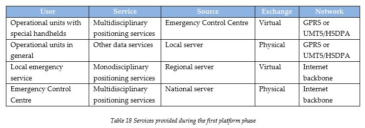
The following two figures illustrate the two architectural designs of the first phase which can be used interchangeably. It should be noted that the dashed and arrowed lines, which represent virtual exchange of information by using application servers, don’t necessarily mean that there is only communication in one direction. The remotely run applications have to react on input given by the people using the handhelds during disasters and test which means that some information is sent back. The first architecture is based on the RDS-dGPS option, where the second shows how the Global DGPS option is structured.
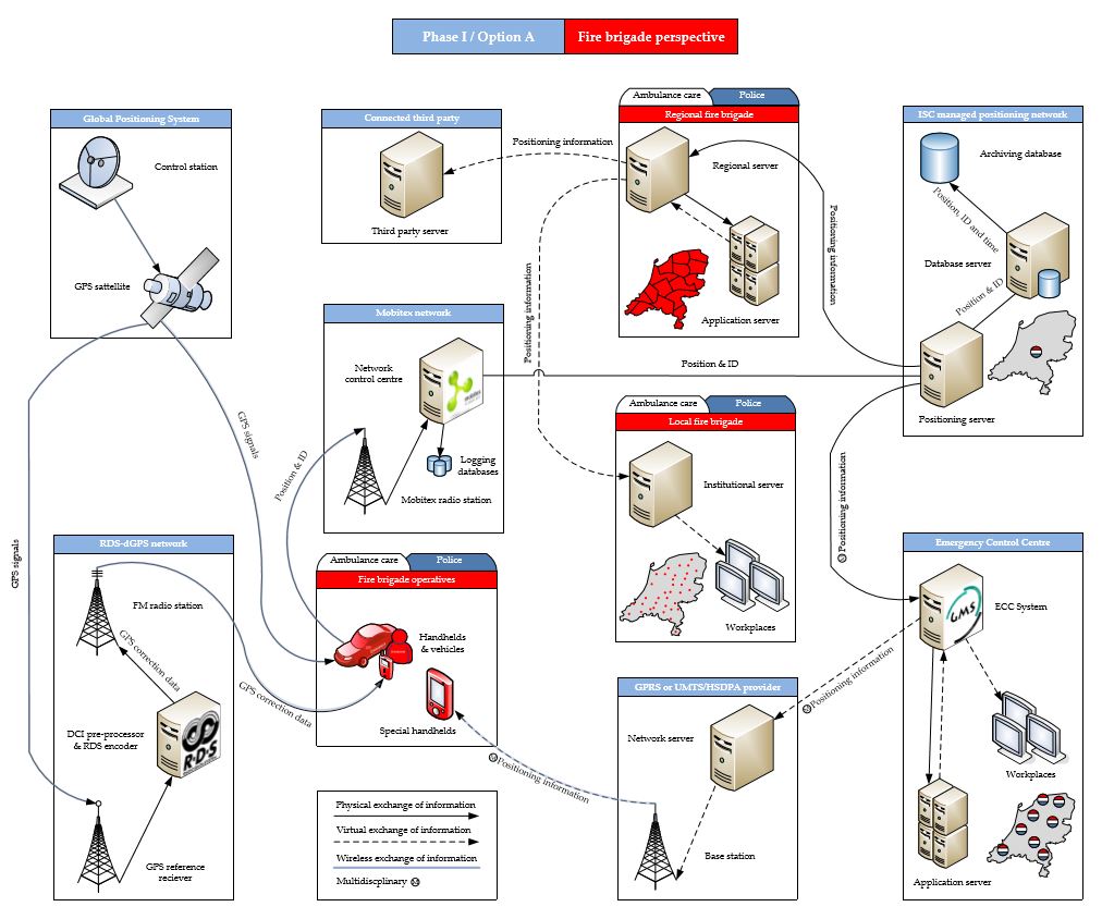
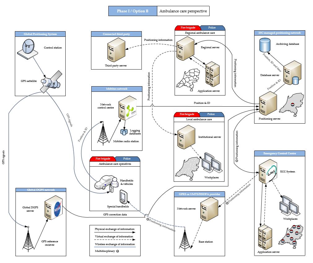
6.4 The second platform phase
The second phase of the positioning platform takes into account the Galileo Positioning System, the EGNOS wide area augmentation system, a WiMAX network and pseudolites for indoor positioning. There are some restrictions on the moment when the second phase can be initiated. The first restriction is based on the availability of Galileo and EGNOS. Both are expected to become available at the same time. The other restriction concerns the availability of WiMAX technology. There is a significant chance that these restrictions aren’t met at the same moment, it is nonetheless advised to implement them at the same time. This is due to the fact that they both influence the hardware design of the handhelds by requiring special receivers and transmitters. The exchange of positioning information and the exchange of data in general towards handhelds will also require handhelds specifically designed for the emergency services. This was brought forward by the police using PDA’s for positioning services for law enforcement officers in Groningen (see table 3, respondent 9). The services they currently use in that pilot strongly resemble the services we expect the second phase to facilitate.
Because of the use of the Galileo and EGNOS system the Netherlands also shows that they act responsibly concerning developments in neighbouring countries and the rest of Europe. They provide an incentive to at least the neighbouring countries to design a similar platform and thereby create options to link the systems together. The choice for WiMAX might have the same effect because of the status WiMAX has been given based on the developments and its expected outcome. It can also be considered as a long term solution because of future needs of emergency services concerning the exchange of large amounts of data towards and from mobile devices. We do have to realize that this research didn’t address data exchange needs of emergency services. This was situated outside of the scope of this research. Data exchange other than positioning data should be considered as the next step in the evolution of the emergency service technologies and shouldn’t be left out of the design of the positioning platform (see figure 23). We do expect the need for exchanging a lot of data and therefore think it is necessary to consider a data network which can facilitate this need.
During the second phase the handhelds receive more GPS signals (i.e. GPS and Galileo) and they also get correction data via the satellites from the EGNOS network. All this information together provides the handhelds the needed data to determine an accurate position. This positioning data is then sent via the WiMAX network towards the positioning platform server. A major evolution that has taken place during the second phase is the ability to send positioning information back to the handhelds. This can be done by the local emergency service or the emergency control centre. In the first phase only the emergency control centres were able to do this and this was also limited to disasters and tests. The local emergency services are also able to send other data directly to the handhelds (e.g. e-mails, short messages, pictures etc.) which was done in the first phase by using the commercially available GPRS and UMTS/HSDPA networks, but the positioning information of the platform is never physically stored on the handhelds. In case a handheld gets stolen, the handheld can be cut off from the network and no connection can be made with the application server.
When disasters happen and someone in the field (e.g. local coordinator of the fire brigade at the incident location) requires information concerning other emergency services, this has to be sent via the emergency control centre, which was also the way this was handled in the first phase. This can be done manually by the emergency control centre employees or automatically by the integrated emergency control centre system or the new control centre system. The latter is done by using scenarios in the software. When the system encounters an emergency it can look up the appropriate scenario and find out whether someone needs additional information based on their authorization level linked to the unique device identification number. This can best be explained by looking at an example.
An emergency is called in at the IECC. The employee asks several questions and inputs this information in the GMS/NMS. The GMS/NMS then analyses the information and determines that this incident requires ambulances, fire fighters and the police. The system also finds out that in this case it is important to provide the handheld of a coordinator of the fire brigade access to an application showing the positions of other emergency services. This is then done automatically. If a situation occurs where someone determines that this is needed and the control centre system didn’t, this person can always call in at the emergency control centre and ask for authorization which is then given manually, but as in all other cases this access has to be logged in the system and might have to be justified in a later stage. The next table illustrates the services provided during the second platform phase.
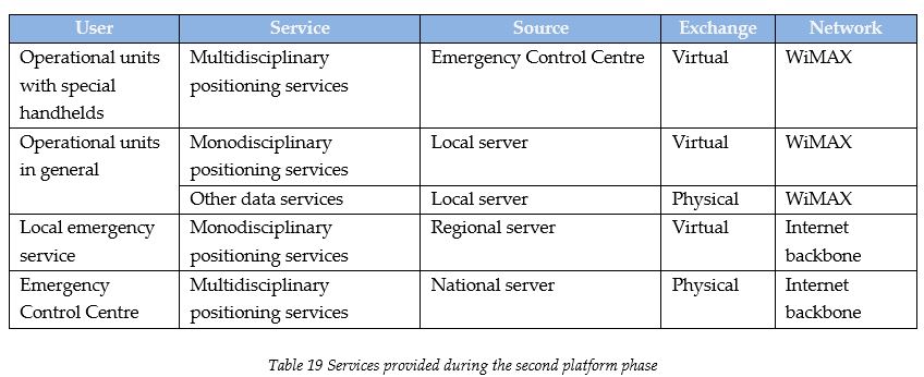
The following figure shows the architectural design of the second phase of the positioning platform.
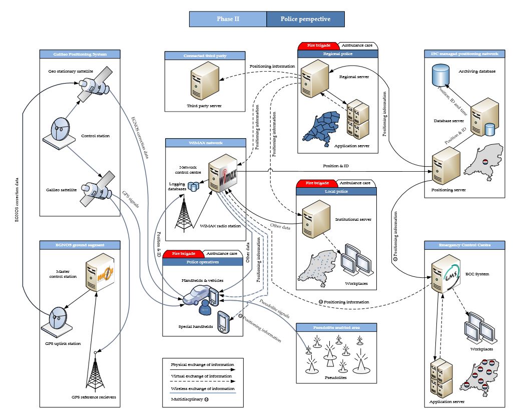
6.5 Research question V
This chapter provided the technological architecture of the positioning platform and thereby addressed the following research question:
V. What does the technological architecture of this positioning platform look like?
The different technological elements have been chosen based on the conditions and requirements determined during the first research phase (see appendix VII). This chapter also showed that it was practically impossible to meet all of the conditions and requirements at the same time. This could only be realized by using two different phases. The first phase was designed in order to bridge the time towards the ideal solution and also provided the option to choose between two different options, namely RDS-dGPS and the Global DGPS network. The second phase didn’t leave any options open and also took out the commercial organizations which were used in the first phase.
7 Organisational arrangements design
7.1 Information exchange
The first organizational variable that has to be addressed is the exchange of information. As mentioned in the conditions and requirements in appendix VII (see table 29) all the emergency control centres should be granted access to the positioning information. This is done by connecting the positioning platform server to the emergency control centres, which is also shown in the technological architectures shown in the previous chapter. The conditions and requirements also showed the need to provide multidisciplinary positioning information at a scene of a disaster when needed. When we look at the technological design we see that this is possible during both phases. The problem here was that this was only allowed as an exception. The police for instance don’t want the other emergency services to know the positions of police officers when this isn’t necessary. In order to comply with this condition we make use of the role the integrated emergency control centre. The emergency control centre employee or the GMS software analyze an emergency call and when multidisciplinary information is needed this can be sent virtually via the WiMAX network or the commercially available GPRS or UMTS/HSDPA network to handhelds of for example local coordinators of the fire brigade.
The local police or ambulance care organizations would like to have positioning information as well, next to its availability at the emergency control centre. This might not seem relevant at first sight, but we do have to acknowledge that positioning information is also very important to individual emergency services in order to effectively coordinate regular operations. Not every action taken by emergency service personnel is directly linked with an emergency. The ambulance care is mostly used for transporting people who aren’t in an emergency, but rather need professional transportation because of their specific needs (see table 2). The police as another example aren’t always acting on emergency calls either. A lot of the time they have to patrol the street and show their presence where people feel unsafe. This is currently mostly done by providing the police officers a list of tasks during the briefing before the starts of their shifts. When their positions are known continuously this can be done more dynamically by alerting services based on their current positions. In order to be able to provide the individual institutions the positioning data they require a direct connection is realized between the positioning platform server and the regional server. The information sent to these servers is limited to the positions of people working for these emergency services, which makes it impossible to acquire positioning information of other emergency services without the involvement of the managing organizations of the positioning platform. Whether or not a police corps is allowed to use the information of a neighbouring corps is something that has to be decided at the national level.
If we assume that the emergency control centre employees and the operational units on the street are accustomed to the routines they have at this moment, we have to take into account the amount of time needed to accustom them to new routines. We think that effective routines are only to be changed if they dramatically increase the effectivity, which we don’t expect to be a natural outcome of the implementation of the positioning platform. The focus should be on providing services without altering existing routines if not necessary. A lot of the processes of the emergency services have been taken over by computers. A nice example of this is the emergency control centre system (GMS). The analysis this software does on the given information is something that had to be done manually in the past. We can expect positioning services to create a lot of information, which can be used to provide innovative services or solutions to problems we didn’t even knew existed. These new services can’t simply be implemented without looking at how they affect the processes the different organizations have come to rely on throughout the years. When we look back at the example given by the police in Groningen about a small town in the United States near Silicon Valley and see what they have achieved, we can’t ignore the fact that there is a lot to be gained in the Netherlands. Positioning services will get introduced but there is a significant possibility that throughout the years these services become integrated and are provided as a package. By nationalizing the positioning services into a positioning platform this type of integration can be realized without the need for each and every individual emergency service to overcome the same obstacles and come to the same conclusion. Regional independence is assured, but it also provides incentives to innovate at this level rather than leaving everything up to the individual local emergency service organizations.
7.2 Commercialization
The emergency services had different notions on the amount of commercialization the platform should be based on. There was also the condition to having a public owned network when the services provided by the platform were to be considered of a critical nature. This is reflected by using two phases in the technological design. During the first phase commercial services are used to provide services for the positioning platform, but this first phase is also considered a phase during which the positioning services still have to develop and therefore can’t turn critical in a short period of time. The multidisciplinary information is sent by using commercial GPRS and UMTS/HSDPA networks, but this is only done during disasters and tests. The second phase of the platform implementation has fully taken care of the dependence of the platform on commercial organizations. The choice for Mobitex was based on their dedication to providing a network for critical services. The choice could have also been made to build an entire data network, but the short term need for the platform and the current development phase of certain promising technologies have convinced us otherwise. We do think that the last phase should be based on public networks, especially because the mobile data networks such as UMTS/HSDPA and GPRS are currently provided by commercial mobile telephony providers. Their dedication to providing voice telephony is not something we consider to change and even if it does, the regular customers of mobile data networks will require a very different reliability of service compared to the needs of the emergency services.
The benefits of having commercial organizations involved can be found in the increased efficiency, higher rate of innovation and lower costs and this can be utilized by making a distinction between infrastructures and services. There is already involvement from commercial organizations during the first phase. The second phase on the other hand is solely based on public networks and technologies. The choice has been made to have commercial organizations operate the WiMAX network. This is done by using a tender every five years (see appendix VIII). The integrity of the network has to be maintained by holding a public organization responsible for the security of the network and its connections. The networks will remain a public asset, but hereby also make use of the advantages of commercialization.
7.3 Management
We do see the need for an organization which manages the platform, whether this should be the ISC or not is something that can be debated, but we do recognize the ISC’s experience in managing the C2000 network. The design explained in the previous chapter does take away some of the police officer role the ISC is blamed to take by other emergency services. Each emergency service is more or less responsible for the way they exchange their own positioning information. There should be some ground rules on connections with other systems, but concerning the exchange of positioning information we can say that we don’t see huge obstacles. This research hasn’t addressed the need for exchanging other information on a continuous basis and can’t therefore say how this should be done. An example can be providing information concerning people who are known to have been violent in the past to the ambulance care. This way they know what to expect to a certain degree, but this information is also very sensitive and it is therefore of great importance that this information doesn’t reach the wrong hands. There is always the possibility to use the same approach for other types of information. By using application servers we are able to provide information which can’t be sent to other parties and can only be used by the organizations that have made an agreement. The downside of only virtually providing information to others is that they aren’t able to directly use this information in their own services, but it does force the emergency services to create applications together with other parties when the exchange of information is needed or has enough potential.
7.4 Number of platforms
During the first phase the option concerning accurate positioning is left open to a certain degree. There is also another option, namely the choice of the ambulance care to join the first phase or not. The other emergency services are on the other hand obliged to join both platform phases. The wish to have a limited amount of platforms is fully realized in the second phase, but this is done in different steps. These steps are described in the following section.
7.5 Implementation
The handhelds and the hardware inside the ambulance care vehicles do need to be Mobitex enabled which they aren’t in all cases at this moment. It would be difficult to convince ambulance care Netherlands to adapt all the hardware to the first phase of the positioning platform. If this is the case our advice would be to keep Ambunet as it is and only oblige the ambulance care to get involved in the second phase of the positioning platform. The added value here would be that they are then able to exchange information with a high data rate by using the public WiMAX network. The positioning services in use by other emergency services at this moment can’t really be considered positioning platforms as they haven’t realized national coverage of their services yet. It would therefore be less difficult to convince these organizations to get involved in the first phase of the positioning platform. Because of the lack of having data exchange ability in the first phase of the platform and the fact that the services aren’t yet considered critical, the different organizations still should be allowed to make use of their chosen commercial data network supplier, which in most cases is based on UMTS/HSDPA and GPRS. These networks are only used in the first phase during disasters and tests. The following figure shows how the two phases are organized.
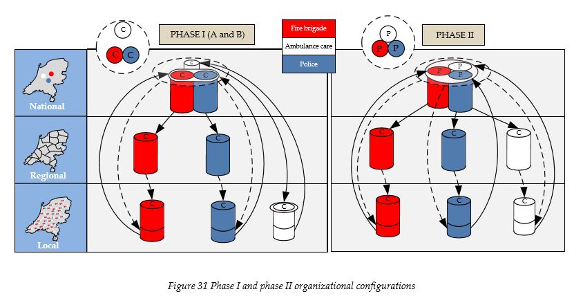
This left configuration shown in the figure is based on the assumption that the ambulance care remains using the Ambunet positioning platform. The police and the fire brigade send their positions to the national server and receive virtual positioning information back locally. They also get multidisciplinary positioning information during disasters at the operational level. All of the networks in this phase are commercially owned and commercially managed. The ambulance care organizations are still able to choose their own network at the local level, as long as they don’t participate in this first platform phase. On the right side of the figure the national level is based on one platform instead of two. All the emergency services provide positioning information and get back this information virtually. Monodisciplinary and multidisciplinary positioning information is also sent back to the operational units. The transition between the first and the second phase is done in facultative steps. The following figure illustrates the different steps that have to be taken.

The upper part of figure 33 represents the first platform phase. The phase is initiated by starting a pilot in Amsterdam. All the emergency services can start in this pilot, but only the police and fire brigades are obliged to participate. The next step is the setting up of the platform on the national level. At this moment all the emergency services are asked to participate on a voluntary basis. This is followed by financial incentives to develop regional positioning service applications. Next to this the funding of other positioning services is stopped to stimulate the emergency services to participate. The last step in this phase is obliging all the police and fire brigades to start using the positioning platform. The second phase also starts out on a voluntary basis. The next step is taking away the budget for using other data exchange networks. After this regional applications are obliged to be used by the entire public safety domain. This is followed by the obligation for each and every emergency service to use all the services provided by the positioning platform, which now included the use of the WiMAX data network.
7.6 Consensus
Creating a public data network immediately is not advised because WiMAX technology is still in the development phase. Other commercial networks could have been chosen, but we would rather invest in a platform which is able to provide the needed reliability when this is needed and this can be realized by using the Mobitex network. Data exchange towards mobile devices is still something the emergency services are experimenting with. It is thus considered something that has to be explored more in order to get a clear picture on the conditions the emergency services might have in the future. Data exchange is facilitated in the second phase and should therefore be left open during the first phase. Positioning services on the other hand are services which are currently considered necessary. This can be seen in the fact that the ambulance care already has realized an independent platform. If the aim is to realize a more reliable and standardized platform which can be used by all the emergency services, the first steps have to be taken as soon as possible. During the first phase of the implementation the benefits of having multidisciplinary positioning data can be explored. This will be done first by the emergency control centres and by realizing integration with the new integrated emergency control centre system (NMS) but also by individual emergency services. The latter exploration process will have to go through the positioning platform which provides us with a check rather than simply giving access to possible insecure experimental services. If for instance the ambulance care would like to have positioning information concerning the whereabouts of certain police officers this would have to be discussed with the police and the positioning platform management, which in this case would be the ISC.
7.7 Covering the costs
The costs that have to be made to develop the positioning platform will have to be covered. This will be done by using a subscription based pricing scheme. The first phase starts out on a voluntary basis. The next step will be obliging the police and the fire brigade to participate in this phase. The ambulance care will keep their voluntary status. The handhelds needed for the first phase are different than those currently in use by the emergency services. It is suggested to make use of the experience with the implementation of the C2000 network and the Tetra based handhelds. Each emergency service has to come up with a handheld/device design. These designs are then brought forward in a tender where companies can participate and get the contract. Using the positioning services will be based on a flat fee subscription. This fee has to be matched with the added value the services the platform is able to provide to each individual stakeholder. The added value for the ambulance care is lower than the added value for the police, which is why we advice to lower the fee for ambulance care in order to stimulate them to participate during the voluntary phase. The second phase requires a WiMAX and Pseudolite network to be rolled out next to the positioning server. These have to be implemented at the national scale and have to be funded by the Dutch government’s Ministry of Interior Affairs and Kingdom Relations. In order to make use of the positioning platform services, special handhelds are needed. This is also done by using a public tender. The goal is to provide every local emergency service new handhelds which are WiMAX and Pseudolite enabled. The C2000 project has shown that the budget was severely underestimated. In order to get a better picture of what the costs could be, the status of large project should be labelled on the platform when the design has been made more concrete.
7.8 Research question VI
This chapter addressed the organizational arrangements of the positioning platform and thereby addresses the following research question:
VI. What are the organizational arrangements for this positioning platform?
The organizational arrangements presented in this chapter brought forward that a balance has to be found concerning contradictory conditions. Simply taking out commercial organizations isn’t the solution. It is better to make use of the advantages of a commercial approach where possible and limit the risks by coming up with specific organizational arrangements. This chapter also brought forward the importance of implementing the technological solution in appropriate steps. These steps should increase the need of the emergency services to make use of the services provided by the positioning platform, but it should also take notice of the importance of having them cooperate in building up the network. By constantly pressuring the emergency services to participate one might undermine the willingness of these organizations. It is therefore of great importance to time these steps in such a way that the outcome for the emergency services is conceived by them as a step forward.
8 Evaluation
This chapter presents a discussion on and the validation of the technological architectures and organizational arrangements which were provided in the previous two chapters. The discussion puts the design in the right context where the validation section describes how the design was validated and which steps have to be taken in the future.
8.1 Discussion
Integrated approach
This research started out by looking at recommendations given by the ACIR advisory group. These recommendations were mostly directed towards realizing a qualitative multidisciplinary information system. It was concluded that positioning services could play an important role in multidisciplinary disaster relief. This resulted in the objective to realize a positioning platform which could meet these conditions. It can be debated whether or not this integrated approach is necessary, due to the fact that information systems can theoretically always be connected to each other. The result of this research would then be the presentation of some standards which could facilitate these connections. The first phase of the research, which brought forward the technological and organizational conditions and requirements of the different emergency services, on the other hand made it clear that the perception of these stakeholders differ concerning reoccurring variables. Take for example the reliability variable. The ambulance care considers Ambunet reliable even though its design hasn’t incorporated the risk of network failure during high demand of the network services. The police on the other hand consider commercial networks to be unreliable and therefore unsuitable for the facilitation of critical services. When these organizations are left the choice between different networks, a huge risk has to be confronted when all the different positioning services are required and only a few are operational during a large-scale disaster.
Added value of the first platform phase
Another point of critique might be that the first platform phase doesn’t provide enough added value and should thus be left out of the design. This thesis already brought forward that the ambulance care has realized a national positioning platform, so why would a phase be needed during which they are allowed to voluntarily participate? The answer to this question is based on the fact that currently no feasible positioning platform can be implemented which can provide the ambulance care any added value. Obliging organizations to participate is something that should only be considered when there are no other options. The interviews with the stakeholders brought forward that next to the ambulance care the police and the fire brigades are also acquiring commercial positioning services. The time until the second phase of the platform has to be bridged, because these organizations are on the verge of developing their own platforms which doesn’t necessarily mean that this will be done on the national level. The more these organizations become dependent on commercial organizations providing positioning services, the more difficult it will become to switch to a new platform. Another risk that can occur here is the dependence of all the emergency services on the ambulance care positioning platform. In this case it would become very difficult for the Ministry of Interior Affairs and Kingdom Relations to address specific needs, which most likely will only have to be addressed in specific situations. One of the most important aspects here would be that of reliability of the services.
Level of standardization
Some might say that the solution provided in this thesis is unachievable. By using application servers and limiting the usability of the positioning information, the emergency services might be reluctant to participate or actively work on the development of the services and the project might therefore fail. The question that we have to ask ourselves here is whether using applications remotely can be considered as the right standard. Both platform phases make use of regional monodisciplinary positioning applications and multidisciplinary applications run by the emergency control centers. During the interviews it was brought forward by all the emergency services that innovation is done differently by different local emergency service organizations. Ideally one positioning service should suffice for an entire discipline, but the fact is that regions or even local emergency services consider themselves to be very different from each other and they therefore also have different requirements and conditions concerning ICT infrastructures and services. The choice was made to focus on the regional scale instead of the local scale because this way the more innovative institutions can take on a leading role and thereby also realize services which are most suited for the local emergency services of the same discipline within the same region. Nothing withholds the regions from co developing services or even realizing a national standard. The choice to have the applications running remotely has been made for security and privacy purposes, but it does pose problems when third parties have to use this information. On the other hand, when this information can simply be sent to third parties, it will become practically impossible to secure the exchange of this information sufficiently and the risk is that this information is used by unauthorized people. In the worst case scenario the same information which is to be used to tackle crime, might be used by criminals to avoid being caught. The assumption we have made here is that organizations that see enough added value for having positioning information, would be willing to develop the needed services. Positioning services presented in this thesis are primarily dynamic services, which most probably require new types of software. At this moment these types of software are still in the development phase and by realizing the first phase as soon as possible sufficient incentive can be given to these parties to develop the needed services and have them run remotely.
8.2 Validation
The validation of the design has been done by interviewing several people from LogicaCMG, namely a system architect and two consultants all working in the field of public safety (see table 3, respondents 5, 6 & 7). The consultants have primarily focussed on organizational aspects where the architect also looked at the technological design. During these interviews the respondents were asked to focus only on the design and to provide comments concerning the validity of the models. A choice had to be made whether to adapt the design to meet these new conditions or to present them separately in this chapter. The choice was eventually made to adapt the design and thereby present a validated product. This primarily had to do with the fact that these comments were of a more detailed level and didn’t require any large adaptations to the design. The discussion presented in the previous section already brought forward the most important points of critique which were also brought forward by the respondents involved in the validation of the designs. The emphasis of the design is based on a balance which had to be made between providing a design which would be preferred by all the stakeholders and providing a design which would meet the needs to have a highly standardized and qualitative multidisciplinary positioning information system for the entire public safety domain. We do consider the interviews with these respondents as a form of validation, but we also recognize the need to have more forms of validation in order to be able to say that the design fully meets the most important conditions and requirements. The following figure illustrates all of the recommended validation steps. The upper part of the blocks represents the validation method and the lower part represents the aspects being validated.
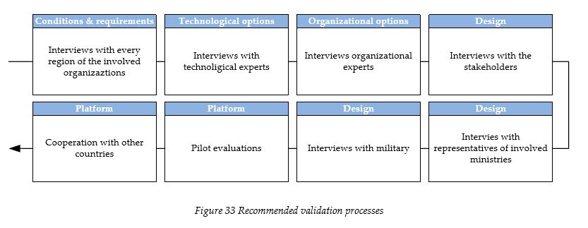
The first aspect that can be validated would be the conditions and requirements of the stakeholders. Due to the limited time which was available for this research, only the most important respondents were chosen and the conditions and requirements were therefore based on a limited amount of interviews. These respondents might have brought forward conditions and requirements which don’t necessarily represent those of the entire discipline. The respondents might even have overlooked some important issues which need to be implemented in the design. It is recommended to conduct a new series of interviews with the emergency services. The respondents would then ideally be representing all the 25 safety regions and all the stakeholders.
The next aspects which can be validated are the technological and organizational options. The technological options brought forward here were based on a literature study on available documentation, but no experts were interviewed who could have provided some new insights in the development of the chosen technologies. This is especially important concerning the relatively new or still to be introduced technologies such as WiMAX, pseudolites but also Galileo. The companies developing these technologies should be contacted and the technologies should be reviewed before the design is considered completely valid. The chapter which presented the organizational options mentioned that the list is endless. Experts in organizational theory might be able to provide specific organizational arrangement which can be used to fine-tune the design or which might even severely alter the technological and organizational architecture. The recommendation here is therefore to have a series of interviews with technological and organizational experts and provide these experts the input gathered during the first series of interviews.
The rest of the validation should be based on the design of this research if the previous validation steps haven’t severely taken away the ground for its underlying argumentations and thereby the design itself. The designs can best be validated by interviewing the stakeholders to determine whether they meet their conditions and requirements. The ACIR advisory panel should also be approached to determine whether it is a suitable solution towards disaster relief. Some representatives from the government, ideally people from the higher echelons of the Ministry of Interior Affairs and Kingdom Relations and the Ministry of Health, Welfare and Sport should also be interviewed to determine whether the design matches their vision on how multidisciplinary ICT infrastructures should be realized. We also strongly recommend interviewing the Dutch military. The Dutch military has a lot of experience with advanced technologies and thereby also with positioning services. They might be able to provide new insights and we consider them as the organization with the most experience concerning the utilization of this type of information.
When the previously mentioned validation steps have been taken the first steps of the implementation of the positioning platform can be taken. As mentioned in the organizational arrangements, a pilot has to be conducted. The choice here is made for Amsterdam, because they are considered to be innovative and are most interesting from a geographical point of view. During this pilot a series of evaluations have to take place to learn from past mistakes and successes. It is also important to look at other countries during this pilot to share experiences and keep each other up to date concerning the developments and thereby the possibilities for international cooperation.
8.3 Research questions VII and VIII
This chapter addressed the evaluation phase of the research and thereby answered the following research questions:
VII. Is the technological architecture valid for the Dutch emergency services? VIII. What are the organizational arrangements for this positioning platform?
This chapter discussed the validity of both the technological architecture as the organizational arrangements of the positioning platform. The argumentation which was used to end up with the eventual design was based on two different phases. In order to fully validate this design and thereby both the technological as the organizational elements, first the conditions and options phase have to be validated. After this the design can be validated. The final validation process is done during the realization of the platform.
9 Conclusions & recommendations
Conclusions
The field of emergency services has proven to be of a very complex nature. The ambulance care is part of a different ministry than the police and the fire brigade and the interviews conducted with the different stakeholders also brought forward a diverse set of demands which made it practically impossible to provide a suitable solution. These interviews also brought forward that there is a lot of development concerning positioning services in the field of public safety. Not every organization is considered innovative and differences can be found even within the same region and the same discipline. The main driver for the need to provide a solution on the short term is the fact that these developments are driving the different organizations apart. Delaying the implementation of a multidisciplinary positioning platform is therefore not considered to be an option. Location based services haven’t yet really reached maturity in the market, navigation systems on the other hand have and this has stimulated different organizations within the field of public safety to look for commercially available positioning services or to develop their own. The Galileo positioning system is highly anticipated but has also suffered from some significant delays. The 3G mobile devices have just recently hit the market and a series of advancements are expected also in this field of technology. By taking into account these developments and by anticipating on future conditions and requirements the emergency services are most likely to have, we have come to the conclusions that we currently can’t provide a suitable positioning platform which can meet all the conditions and requirements brought forward by the stakeholders at the same time. We did on the other hand recognize the need to have a platform and have therefore provided the solution in two separate phases.
The first phase almost fully accommodates the current needs of the police and the fire brigade, but it doesn’t meet the need to exchange other data than positioning information. Because of this fact the choice has been made to leave the option open concerning the use of commercially available GPRS or UMTS/HSDPA networks. The need for accurate positioning information is also something that is debated which has forced us to give the option to choose between RDS-dGPS and the Global DGPS network. The latter lacks the ability to have accurate positioning information on the street, but it does provide this at the local emergency service organizations and the IECC. The data network being used in the first phase is based on the Mobitex network and general GPS positioning in combination with the above mentioned DGPS options. Another problem of the first phase is the fact that it doesn’t provide significant added value to the ambulance care, which is why we have chosen to keep their participation during this phase voluntary. The second phase of the platform is a phase in which eventually all the emergency services are obliged to participate. This phase is based on pseudolite technology, realizing ubiquitous and accurate positioning in combination with the Galileo signals and the EGNOS augmentation system. It also makes use of a WiMAX data network which is able to facilitate the exchange of large amounts of data towards and from mobile devices. This network thereby enables us to provide monodisciplinary positioning information on the street, which means that a police officer is then able to see where his colleagues are. There was also the need to have multidisciplinary positioning information during disasters. This is enabled during the first phase by using commercial GPRS or UMTS/HSDPA networks. During the second phase this is realized by using the WiMAX network, but both phases limit the exchange of this information to disasters and tests. The positioning information, both mono and multidisciplinary, is provided virtually by using application servers. These application servers are implemented regionally and at the emergency control centres. In order to be able to use the positioning services, applications have to be developed at least at the regional level. Connections with third parties also have to be realized at this level, which therefore requires negotiations with the other institutions of the same discipline within their respective region. The security of the networks is partly addressed by using these application servers, but it is also recommended to have a public organization audit the security of the positioning information at the Mobitex network during the first phase. The WiMAX network which is used in the second phase is managed by a commercial organization, which also has to be checked by the same public organization in order to be able to rely on enough political support. These two phases together form the design of the research. They have been validated by interviewing people with experience in the field of public safety in combination with information technology. Due to the limited available time a list of validation processes has been given which can be used to fully validate the design.
Recommendations
There are some recommendations we would like to give concerning future research. During the interviews it became clear that the public safety sector in the Netherlands consists of emergency service disciplines which barely communicate with each other. There is a lot of mistrust which has to be addressed. We therefore recommend to bring them together and have them exchange their ideas concerning the development of multidisciplinary information systems and services. We also strongly recommend conducting a research concerning the need to exchange data towards and from mobile devices. This research has already brought forward that there is an increasing need for mobile data networks and we already brought forward that we see this as the following step that has to be taken. The exchange of information in general has to be streamlined and a suitable design has to be made which can facilitate the exchange of multidisciplinary information. We would also like to recommend a research on the effects of forcing an integrated approach on the sector. The problems concerning the ambulances not being able to reach patients within the 15 minute time frame [38] was linked to having the integrated emergency control centres. The current processes used by the different emergency services have been aligned throughout the years. Changing these processes might have some unforeseen negative effects, which is why we recommend looking at this aspect instead of only focussing on where integration can be realized. As a final recommendation we strongly advice looking at the fact that ambulance care belongs to a different ministry. The Ministry of Health, Welfare and Sport has a smaller budget, but also looks at different aspects than the Ministry of Interior Affairs and Kingdom Relations. The problem has been solved partly by putting the GHOR under the Ministry of Interior Affairs and Kingdom Relations, but the fact is that the GHOR only represents a set of guidelines and some additional vehicles. The people working for GHOR are the same people working for the commercial and public ambulance care organizations and they have to be approached as a care taking entity or be part of the same ministry. It might be possible to do this by looking at their A1 and A2 code operations as public safety affairs and the B code operations as them being part of the Ministry of Health, Welfare and Sport (see figure 9).
Reflection
The reflection shown in this part of the thesis is a personal note on my experiences during the research
When I was writing the research proposal, which had to be agreed upon by both the University and the company chosen to facilitate the research (i.e. LogicaCMG), some obstacles were encountered. A suggestion was first provided by the company which didn’t fully comply with the requirements of the University. This triggered me to come up with a suitable topic addressing both organizations expectations. The risk that was taken here is that one can end up with a rather abstract subject and thereby an unmanageable research concerning the limited time frame. The public safety domain was at that moment rather new to me. My ideas on this subject were based on lectures, books and publications, but never based on conversations I would have had with people from these organizations.
The ideal end result for me was to come up with a Master’s thesis which addressed an existing or unaware need or which shed a new light on known issues or subjects. During the research one of the respondents brought forward that he had recently received a draft version of a document from the government, which I unfortunately wasn’t permitted to read. This document brought forward the same subject as my research. Next to the reactions of the respondents during the interviews, I considered this as proof that this subject was being picked up synchronously to my research. The first phase of my research addressed the many conditions to which a positioning platform had to comply. It came to my attention that this step was entirely skipped by this organization because the document was based on assumptions without getting input from the involved organizations.
The subject of the research is in fact a combination of terms which can’t be found in existing publications. There are on the other hand a lot of publications for each technology that can be used and on how public organizations function or how their functioning can be improved. A positioning platform is something that hasn’t yet been realized for the general public, which tempts us to sit back and wait before we address such a need for public organizations. It is on the other clear that positioning services or location based services can be very interesting for the emergency services, it is rather easy to come up with scenarios in which such services can be helpful. Looking in the future is always difficult and might be even counterproductive if the wrong conclusions are drawn based on unrealistic results or an incorrect interpretation of realistic results. It is on the other hand very important to look at the current developments, which in this case were rather compelling and practically screamed for attention. Being proactive and designing flexible solutions is something that is very important when it comes to technological innovation, the more organizations deviate and create their own solutions, the more difficult it becomes to bring them all together in the future.
Literature
Books & publications
[1] ACIR, Adviescommissie Coördinatie ICT Rampenbestrijding. (2005). De Vrijblijvendheid Voorbij: Op naar een effectieve multidisciplinaire informatievoorziening bij grootschalig gezamenlijk optreden in onze gedecentraliseerde eenheidsstaat [electronic version]. Den Haag, the Netherlands: Ministerie van Binnenlandse Zaken en Koninkrijksrelaties
[2] Ambulancezorg Nederland (2006, November 15). Beleidsnotitie Dynamisch AmbulanceManagement, Retrieved on March 25, 2007, from http://www.ambulancezorgnederland.nl/pdf/061115_eindversie%20beleidsdocument% 20DAM%202006.pdf
[3] Ambulancezorg Rotterdam-Rijnmond (2007). Informatievoorziening & ICT, Rotterdam. Internal document.
[4] Barnes, J., Rizos, C., Wang, J., Small, D., Voigt, G., & Gambale, N. (2004) High precision indoor and outdoor positioning using LocataNet [electronic version]. Journal of Global Positioning Systems, 2(2), 73-82
[5] Beauregard, S. (2006 March). A Helmet-Mounted Pedestrian Dead Reckoning System [electronic version]. In Proceedings of the 3rd International Forum on Applied Wearable Computing, Bremen, Germany.
[6] Becvar, Z., Zelenka, J. & Bestak, R. (2006, September 26). Comparison in handovers in UMTS and WiMAX. Fireworks. Retrieved April 2, 2007, from http://fireworks.intranet.gr/fireworks_docspublic/Fireworks_6CTUPB005a.pdf
[7] Boeije, R., Obbohat, P., van Roon, V. & de Leeuw, G. (2007, February 2) Terrorist attacks on Queens-day in Amsterdam. Available on request
[8] Crozier, E. & Kelin, A. (2007). WiMAX’s technology for LOS and NLOS environments [electronic version]. WiMAX Forum, Mountain View, p10
[9] Chen, M.Y., Sohn, T., Chmelev, D., Haehnel, D., Hightower, J., Hughes, J. et al (2006 September). Practical metropolitan-scale positioning for GSM phones [electronic version]. In Proceedings of the Eighth International Conference on Ubiquitous Computing. Ervine, CA
[10] Dodson, A., Meng, X., Roberts, G., Cosser, E., Barnes, J. & Rizos, C. (2003 April). Integrated Approach of GPS and Pseudolites for Bridge Deformation Monitoring [electronic version]. In Proceedings GNSS2003, Graz, Viena
[11] Fontana, R. & Gunderson, S. (2002 May) Ultra Wideband Precision Asset Location System [electronic version]. In Proceedings of IEEE Conference on Ultra Wideband Systems and Technologies, Baltimore, MD
[12] Hallberg, J. & Nilsson, M. (2002). Positioning with Bluetooth, IrDA and RFID, Master’s Thesis, Lulea University of Technology, Lulea, Sweden. Retrieved May 13 2007, from http://media.csee.ltu.se/publications/2002/hallberg02positioning.pdf
[13] Holma, H. & Toskala, A. (2000). WCDMA for UMTS – Radio Access for Third Generation Mobile Communications [electronic version]. John Wiley & Sons
[14] Lachapelle, G., Kuusniemi, H., Dao, D.T.H., MacGougan, G., & Cannon, M.E. (2003) HSGPS Signal Analysis and Performance Under Various Indoor Conditions [electronic version]. Navigation, Journal of The Institute of Navigation 51(1), 29-43.
[15] Matsuoka, M., Rock, S.M. & Bualat, M.G. (2004, April) Autonomous Deployment of a SelfCalibrating Pseudolite Array for Mars Rover Navigation [electronic version], In Proceedings of the 2004 IEEE Position, Location and Navigation Symposium 2004, Monterey, CA
[16] Ministerie Binnenlandse Zaken en Koninkrijksrelaties (1999, August) Meldkamer Breed, 2(5), Retrieved June 11, 2007, from http://www.minbzk.nl/aspx/download.aspx?file=/contents/pages/2825/meldkamerbreed _5_9-99.pdf
[17] Ministerie Binnenlandse Zaken en Koninkrijksrelaties. (2004) ICT-kanskaart Brandweer. Den Haag, the Netherlands: Ministerie BZK. Retrieved on June 14, 2007, from http://www.minbzk.nl/aspx/download.aspx?file=/contents/pages/8109/rapportageictkanskaartbrandweerdd27juli2004exclbijlagen.pdf
[18] Ministerie Binnenlandse Zaken en Koninkrijksrelaties. (2006) Rapport eindevaluatie C2000. Den Haag, the Netherlands: Ministerie BZK. Retrieved on September 24, 2007, from http://www.verbinding.nl/Eindevaluatie%20C2000.pdf
[19] Mintzberg, H. (1983). Structure in fives: Designing effective organizations. New York: PrenticeHall
[20] Nilsson, M., Hallberg, J. & Synnes, K. (2003 February). Positioning with Bluetooth [electronic version], Paper presented in 10th International Conference on Telecommunications ICT2003, Tahiti, Papeete, French Polynesia
[21] Politie Nederland. (2006) Wenkend Perspectief: Strategische visie op politieel informatiemanagement & technologie 2006-2010 [electronic version]. Driebergen, the Netherlands: Ministerie van Binnenlandse Zaken en Koninkrijksrelaties
[22] Rao, B. & Minakakis, L. (2003). Evolution of mobile location-based services [electronic version]. Communications of the ACM, 46(12)
[23] van Damme, E. (2002 May). The Dutch UMTS-Auction [electronic version] CESifo Working Paper, No. 722(9).
[24] van der Bosch, A. (2005, June 27). Visiedocument voor de meldkamer. Paramedics Worldwide, Retrieved July 15, 2007, from http://www.minbzk.nl/contents/pages/43426/visiedocumentmeldkamer-eindversie1.doc
[25] Varshavsky, A., Chen, M., de Lara, E., Froehlich, J., Haehnel, D., Hightower, J. et al (2006 April). Are GSM phones THE solution for localization? [electronic version]. Presented in IEEE Workshop on Mobile Computing Systems and Applications, IEEE Computer Society Press, Los Alamitos
[26] Wang J., Tsujii, T., Rizos, C. Dai, L. & Moore, M. (2001). GPS and pseudo-satellites integration for precise positioning [electronic version]. Geomatics Research, Australasia, 74, 103-117
[27] Wet rampen en zware ongevallen. (2007) hoofdstuk 1, artikel 1
[28] Zumberge, J. & Gendt, G. (2001) The Demise of Selective Availability and Implications for the International GPS Service [electronic version], Phys. Chem. Earth (A) 26, 637-644
Internet
[29] C2000: http://www.c2000.nl (Last checked: August 9th 2007)
[30] Computable: UMTS wordt vaak teruggeschakeld naar GSM: http://www.computable.nl/topic_nieuws.jsp?rubriek=1277034&id=1969878 (Last checked: August 9th 2007)
[31] Directorate-General Energy and Transport: European Satellite Navigation System: http://ec.europa.eu/dgs/energy_transport/galileo/applications/index_en.htm (Last checked: August 20th 2007)
[32] Faculteit, Techniek, Bestuur en Management: http://www.tbm.tudelft.nl (Last checked: August 20th 2007)
[33] Flash Services: Binnenhuisdekking C2000 en ASTRID: http://www.flash-services.com/topnl/communicatie+systemen/toepassingen/binnenhuisdekking+c2000+en+astrid (Last checked: August 20th 2007)
[34] GeoMETIUS: RDS-dGPS: http://www.geometius.nl/product.php?id=470&active_menu_item=24 (Last checked: August 9th 2007)
[35] GPS World: Galileo, GLONASS, and GPS: http://www.gpsworld.com/gpsworld/article/articleDetail.jsp?id=300303 (Last checked: August 9th 2007)
[36] ICT-Service Centrum Politie, Justitie en Veiligheid U.A.: http://www.isc.nl (Last checked: August 9th 2007)
[37] Mobitex: Frequently Asked Questions: http://www.mobitex.com/company/faq.asp (Last checked: August 9th 2007)
[38] Netwerk: Ambulancezorg schiet tekort: http://www.netwerk.tv/archief/4868818/821 (Last checked: August 9th 2007)
[39] Planet: KPN stelt datadienst Telfort buiten gebruik: http://www.planet.nl/planet/show/id=118880/contentid=840420/sc=376bba (Last checked: August 9th 2007)
[40] Planet : UMTS-controle pas na verkoop Orange http://www.planet.nl/planet/show/id=62967/contentid=863848/sc=3268e3 (Last checked: August 9th 2007)
[41] Politie: Wat doet de Nederlandse politie? http://www.politie.nl/Overige/Overdepolitie/watdoetdepolitie/ (Last checked: September 27th 2007)
[42] RAM Mobile Data: http://www.ram.nl (Last checked: August 9th 2007)
[43] Terrestrial Trunked Radio: http://www.tetramou.com (Last checked: August 9th 2007)
[44] Trimble: GPS for precision agriculture: http://www.trimble.com/ag_gps.shtml (Last checked: August 9th 2007)
[45] US Embassy Ireland: U.S., EU working on Global Positioning Systems Agreement http://dublin.usembassy.gov/ireland/systems_agree.html (Last checked: August 9th 2007)
[46] Wikipedia: Bijlmerramp: http://nl.wikipedia.org/wiki/Bijlmerramp (Last checked: August 9th 2007)
[47] Wikipedia: General Packet Radio Service: http://en.wikipedia.org/wiki/General_Packet_Radio_Service (Last checked: August 9th 2007)
[48] Wikipedia: Local Area Augmentation System: http://en.wikipedia.org/wiki/LAAS (Last checked: September 27th 2007)
[49] Wikipedia: Vuurwerkramp Enschede: http://nl.wikipedia.org/wiki/Vuurwerkramp_Enschede (Last checked: August 9th 2007)
[50] Zenitel: Zenitel maakt verbinding, overal: http://www.zenitel.nl/cms/page/160 (Last checked: August 20th 2007)
Presentations / Lectures
[51] Herder, P. (2007) Functioneel ontwerpen SPM3120. Delft, The Netherlands: TU Delft
[52] Syrjarinne, J. (2001) 38th Meeting 15 Anniversary, CGSIC, Nokia Mobile Phones
[53] Verbree, E. & Tiberius, C. (2007) Location Based Services. Delft, The Netherlands: TU Delft
[54] Worm, E. (2007). EMS in the Netherlands. 15th World Congress on Disaster and Emergency Medicine, AmbulanceZorg Nederland, Retrieved on August 24, from http://www.ambulancezorgnederland.nl/pdf/070514_presentaties_WCDEM2007.pdf